IMAGES TAKEN NEAR TO
Peulwys Lane, COLWYN BAY, LL29 8YE
Introduction
This page details the photographs taken nearby to Peulwys Lane, LL29 8YE by members of the Geograph project.
The Geograph project started in 2005 with the aim of publishing, organising and preserving representative images for every square kilometre of Great Britain, Ireland and the Isle of Man.

There are currently over 7.5m images from over14,400 individuals and you can help contribute to the project by visiting https://www.geograph.org.uk
Image Map (Loading...)


Getting Data...Please wait
Leaflet Map data © OpenStreetMap
Images are licensed for reuse under creativecommons.org/licenses/by-sa/2.0
Notes
- Clicking on the map will re-center to the selected point.
- The higher the marker number, the further away the image location is from the centre of the postcode.
Image Listing (10 Images Found)
Images are licensed for reuse under creativecommons.org/licenses/by-sa/2.0
Image
Details
Distance
2
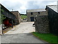
Gwynt o'r De
A wonderful weathervane on top of an immaculate store shed, with a very neat heraldic dragon and Welsh direction indicators.
Image: © Jonathan Wilkins
Taken: 23 May 2011
0.10 miles
4
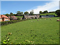
Pasture by Fferm Peulwys
Sheep are grazing in the steep field below the farm. Despite the hilly terrain, the encroachment of modern housing on the agricultural landscape appears to be relentless. The slopes above Colwyn Bay have long been a refuge for people who wish to avoid the realities of urban life.
Image: © Jonathan Wilkins
Taken: 23 May 2011
0.13 miles
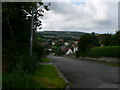
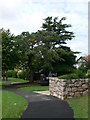
5
Children's playground off Peulwys Lane, Old Colwyn
Image: © Eirian Evans
Taken: 15 Aug 2007
0.18 miles
6
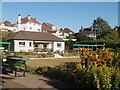
Clwb bowlio Hen Golwyn / Old Colwyn Bowling Club
Image: © Ceri Thomas
Taken: 19 Jun 2010
0.19 miles
7
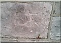
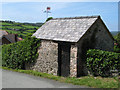
Ordnance Survey Cut Mark
This OS cut mark can be found on the wall NW side of Abergele Road. It marks a point 48.666m above mean sea level.
Image: © Adrian Dust
Taken: 18 Jun 2021
0.21 miles
8
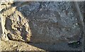
Ordnance Survey Cut Mark
This OS cut mark can be found on the wall of No2 Llysfaen Road. It marks a point 43.366m above mean sea level.
Image: © Adrian Dust
Taken: 17 Jun 2021
0.21 miles
9
Wynn Gardens, Old Colwyn
This section of Wynn Gardens, the Sensory Garden, includes a group of sculptures by Joss Smith. The centre-piece is a tactile sculpture made of different coloured slate blocks from North West Wales’ slate quarries, and in its shape and form, reflecting the surrounding landscape and seascape. The sensory garden was opened in 2004.
Image: © Eirian Evans
Taken: 15 Aug 2007
0.23 miles
10
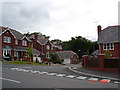
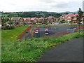
New houses at Old Colwyn
Part of the new housing estates at Old Colwyn
Image: © Dot Potter
Taken: 23 Jul 2005
0.25 miles