IMAGES TAKEN NEAR TO
Tan Y Graig Road, COLWYN BAY, LL29 8UE
Introduction
This page details the photographs taken nearby to Tan Y Graig Road, LL29 8UE by members of the Geograph project.
The Geograph project started in 2005 with the aim of publishing, organising and preserving representative images for every square kilometre of Great Britain, Ireland and the Isle of Man.

There are currently over 7.5m images from over14,400 individuals and you can help contribute to the project by visiting https://www.geograph.org.uk
Image Map (Loading...)


Getting Data...Please wait
Leaflet Map data © OpenStreetMap
Images are licensed for reuse under creativecommons.org/licenses/by-sa/2.0
Notes
- Clicking on the map will re-center to the selected point.
- The higher the marker number, the further away the image location is from the centre of the postcode.
Image Listing (6 Images Found)
Images are licensed for reuse under creativecommons.org/licenses/by-sa/2.0
Image
Details
Distance
1
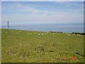
Ty Mawr Llysfaen
Looking out from the highpoint at Llysfaen over the North Wales Coast
Image: © Dot Potter
Taken: 8 Jul 2005
0.07 miles
2
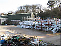
Footpath and waste
Redundant materials stockpiled on open-air stillages are complemented by rubbish dumped since manufacturing ceased some months ago. The footpath runs through the centre of the concrete yard, which was originally the farmyard of Ty Mawr.
Image: © Jonathan Wilkins
Taken: 23 Jan 2009
0.11 miles
3
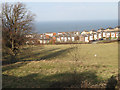
Grazing by Peulwys Lane
Sheep on grazing land above the housing estate, seen from Ty Mawr farmyard.
Image: © Jonathan Wilkins
Taken: 23 Jan 2009
0.15 miles
4
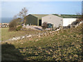
Ty Mawr enterprise park
Large modern buildings belonging to a PVC window manufacturer sit astride the public footpath that runs from the old farm onto the hillside. The stile can be seen where the footpath crosses the wall.
Image: © Jonathan Wilkins
Taken: 23 Jan 2009
0.16 miles
5
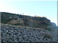
View up from the Coastal Path
The A55 Expressway runs parallel to the Coast Path. Beyond is Llanddulas Quarry, and perched on top with a great view to the sea but a rather precarious position, are houses.
Image: © Eirian Evans
Taken: 14 Jan 2012
0.19 miles
6
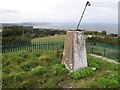
Mynydd Marian
Trig on top of reservoir, fence easily climbed via gate handle. Very good views while I enjoyed a good wander along this summit ridge on a grey mild Friday.
Name: Mynydd Marian
Hill number: 5167
Height: 208m / 682ft
Area: 30C: Llandudno to Wrexham
Class: Hu
Grid ref: SH 88834 77426
Summit feature: trig point: OS measurement
Drop: 103m
Col: 105m SH889764
Image: © Rude Health
Taken: 15 Oct 2010
0.24 miles