IMAGES TAKEN NEAR TO
Bron Y Llan Road, COLWYN BAY, LL29 8TT
Introduction
This page details the photographs taken nearby to Bron Y Llan Road, LL29 8TT by members of the Geograph project.
The Geograph project started in 2005 with the aim of publishing, organising and preserving representative images for every square kilometre of Great Britain, Ireland and the Isle of Man.

There are currently over 7.5m images from over14,400 individuals and you can help contribute to the project by visiting https://www.geograph.org.uk
Image Map (Loading...)


Getting Data...Please wait
Leaflet Map data © OpenStreetMap
Images are licensed for reuse under creativecommons.org/licenses/by-sa/2.0
Notes
- Clicking on the map will re-center to the selected point.
- The higher the marker number, the further away the image location is from the centre of the postcode.
Image Listing (4 Images Found)
Images are licensed for reuse under creativecommons.org/licenses/by-sa/2.0
Image
Details
Distance
1
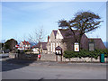
Village hall
Village hall at the crossroads between the Dolwen and Llanddulas roads.
Image: © Jonathan Wilkins
Taken: 19 Mar 2008
0.13 miles
3
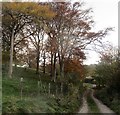
Y lon i Blas Farm / The lane to Plas Farm
Image: © Ceri Thomas
Taken: 10 Nov 2018
0.22 miles
4
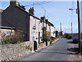
Village street
Cottages beneath the limestone ridge of Mynydd Marian.
Image: © Jonathan Wilkins
Taken: 19 Mar 2008
0.23 miles