IMAGES TAKEN NEAR TO
Severn Road, COLWYN BAY, LL29 8RD
Introduction
This page details the photographs taken nearby to Severn Road, LL29 8RD by members of the Geograph project.
The Geograph project started in 2005 with the aim of publishing, organising and preserving representative images for every square kilometre of Great Britain, Ireland and the Isle of Man.

There are currently over 7.5m images from over14,400 individuals and you can help contribute to the project by visiting https://www.geograph.org.uk
Image Map
Images are licensed for reuse under creativecommons.org/licenses/by-sa/2.0
Notes
- Clicking on the map will re-center to the selected point.
- The higher the marker number, the further away the image location is from the centre of the postcode.
Image Listing (8 Images Found)
Images are licensed for reuse under creativecommons.org/licenses/by-sa/2.0
Image
Details
Distance
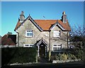
1
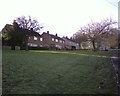
Maes-y-Glyn, Colwyn Bay
Home to my Mothers, Nice!
Image: © colwynboy
Taken: 3 Jan 2010
0.03 miles
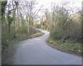
2
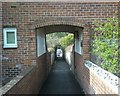
Lane linking Maes y Glyn & Maes y Fron, Glyn Estate, Colwyn Bay
Image: © colwynboy
Taken: 8 Apr 2010
0.08 miles
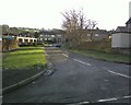
5
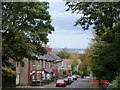
View from Glyn
Glyn - high above the town of Colwyn Bay
Image: © Dot Potter
Taken: 29 Oct 2005
0.14 miles
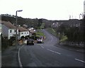
8
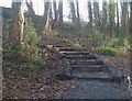
Grisiau yng Nghoed y Dingle / Steps in Dingle Woods
Image: © Ceri Thomas
Taken: 2 Jan 2010
0.20 miles