
IMAGES TAKEN NEAR TO
Wynnstay Road, COLWYN BAY, LL29 8NB
Introduction
This page details the photographs taken nearby to Wynnstay Road, LL29 8NB by members of the Geograph project.
The Geograph project started in 2005 with the aim of publishing, organising and preserving representative images for every square kilometre of Great Britain, Ireland and the Isle of Man.

There are currently over 7.5m images from over14,400 individuals and you can help contribute to the project by visiting https://www.geograph.org.uk
Image Map
Images are licensed for reuse under creativecommons.org/licenses/by-sa/2.0
Notes
- Clicking on the map will re-center to the selected point.
- The higher the marker number, the further away the image location is from the centre of the postcode.
Image Listing (480 Images Found)
Images are licensed for reuse under creativecommons.org/licenses/by-sa/2.0
Image
Details
Distance
2
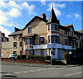
Nacro Cymru, Colwyn Bay
The Nacro office is located on the ground floor here at 13 Prince's Drive, on the corner of Hawarden Drive.
Nacro was formed in 1966 from the National Association of Discharged Prisoners’ Aid Societies.
Nacro describes itself as a champion of social justice which continues to put crime prevention and reduction at its core. Nacro helps the most vulnerable in the community to change their lives and to reach their full potential and aspirations. This is achieved by addressing social exclusion, inequality of opportunity and deprivation.
Image: © Jaggery
Taken: 23 Feb 2016
0.03 miles
3
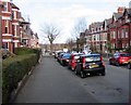
Hawarden Road, Colwyn Bay
Viewed from the Conway Road end looking along Hawarden Road towards Prince's Drive.
Image: © Jaggery
Taken: 23 Feb 2016
0.04 miles
4
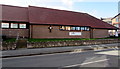
Prince's Drive Baptist Church, Colwyn Bay
This is the Prince's Drive side of the church on the corner of Hawarden Road.
Image: © Jaggery
Taken: 23 Feb 2016
0.04 miles
5

Wynnstay Road, Colwyn Bay
Viewed from the corner of the A547 Conway Road looking along Wynnstay Road towards Prince's Drive. The two white arrows painted on the road surface show that Wynnstay Road is a one-way road, towards the camera.
Image: © Jaggery
Taken: 23 Feb 2016
0.04 miles
6
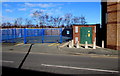
Electricity substation on the north side of Prince's Drive, Colwyn Bay
Located almost opposite the Hawarden Road junction.
The yellow label on the substation shows SP Manweb plc.
The substation identifier is 07-8479-4.
Image: © Jaggery
Taken: 23 Feb 2016
0.05 miles
7
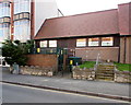
Electricity substation on the south side of Prince's Drive, Colwyn Bay
Located opposite the Picture House pub. http://www.geograph.org.uk/photo/4640115
Yellow labels on the substation show SP Manweb plc.
Image: © Jaggery
Taken: 23 Feb 2016
0.05 miles
8
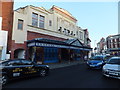
The Picture House
A J. D. Wetherspoon outlet in what used to be one of Colwyn Bay's cinemas.
Image: © Richard Hoare
Taken: 15 Feb 2013
0.05 miles
9
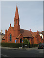
English Presbyterian Church
Originally there were Welsh and English causes worshipping together at another site on Conway Road, but continuing difficulties led to the Welsh building their own Capel Engedi nearby Image Ultimately this church was built to replace the building of the English cause between 1890 and 1891. It is executed in red brick, tile and terra-cotta and presents a very red appearance altogether.
Image: © Jonathan Wilkins
Taken: 17 Mar 2009
0.05 miles
10
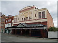
The Former Princess Picture Theatre, Colwyn Bay
Built in 1922, a Neo-Egyptian facade was added in 1932. It was opened as a Wetherspoon public house in 1998.
Image: © Chris Andrews
Taken: 31 Jul 2017
0.05 miles