IMAGES TAKEN NEAR TO
Canning Road, COLWYN BAY, LL29 8EB
Introduction
This page details the photographs taken nearby to Canning Road, LL29 8EB by members of the Geograph project.
The Geograph project started in 2005 with the aim of publishing, organising and preserving representative images for every square kilometre of Great Britain, Ireland and the Isle of Man.

There are currently over 7.5m images from over14,400 individuals and you can help contribute to the project by visiting https://www.geograph.org.uk
Image Map
Images are licensed for reuse under creativecommons.org/licenses/by-sa/2.0
Notes
- Clicking on the map will re-center to the selected point.
- The higher the marker number, the further away the image location is from the centre of the postcode.
Image Listing (262 Images Found)
Images are licensed for reuse under creativecommons.org/licenses/by-sa/2.0
Image
Details
Distance
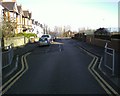
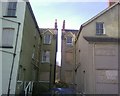
3
Junction of Greenfield, Trevor & Lawson Roads. Colwyn Bay
Image: © colwynboy
Taken: 3 Jan 2010
0.04 miles
5
Disused flats, Greenfield Road, Colwyn Bay.
Image: © colwynboy
Taken: 10 Apr 2010
0.07 miles
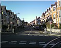
6
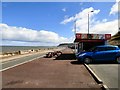
Colwyn Bay Promenade / Bae Colwyn Promen
Looking eastwards / Edrych tua'r dwyrain.
Image: © Gerald England
Taken: 25 Apr 2016
0.07 miles
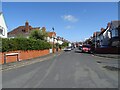
9
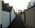
Lane between Greenfield Rd & Pendorlan Ave, Colwyn Bay
Image: © colwynboy
Taken: 3 Jan 2010
0.08 miles
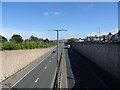
10
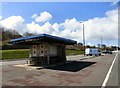
Shelter on the Promenade / Shelter ar y Promen
Image: © Gerald England
Taken: 25 Apr 2016
0.09 miles