IMAGES TAKEN NEAR TO
Woodland Park, COLWYN BAY, LL29 7ER
Introduction
This page details the photographs taken nearby to Woodland Park, LL29 7ER by members of the Geograph project.
The Geograph project started in 2005 with the aim of publishing, organising and preserving representative images for every square kilometre of Great Britain, Ireland and the Isle of Man.

There are currently over 7.5m images from over14,400 individuals and you can help contribute to the project by visiting https://www.geograph.org.uk
Image Map
Images are licensed for reuse under creativecommons.org/licenses/by-sa/2.0
Notes
- Clicking on the map will re-center to the selected point.
- The higher the marker number, the further away the image location is from the centre of the postcode.
Image Listing (188 Images Found)
Images are licensed for reuse under creativecommons.org/licenses/by-sa/2.0
Image
Details
Distance
1
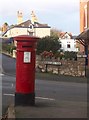
Blwch post o gyfnod Edward VII / An Edward VIIth postbox
Image: © Ceri Thomas
Taken: 2 Jan 2010
0.03 miles
2
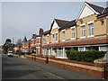
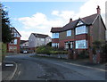
Hillside Road
Another splendid terrace, this one displaying very artistic brickwork in red and yellow with a decorative tiling motif on the continuous porch. Many of the corner buildings at the junctions sport elegant turrets as can be seen in the distance here.
Image: © Jonathan Wilkins
Taken: 17 Mar 2009
0.07 miles
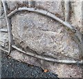
4
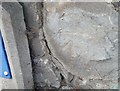
Ordnance Survey Cut Mark
This OS cut mark can be found on the wall between Nos22 & 24 Coed Pella Road. It marks a point 54.657m above mean sea level.
Image: © Adrian Dust
Taken: 14 Sep 2019
0.09 miles
5
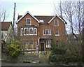
Rivieres Avenue house, Colwyn Bay
The house on the right is on the corner of Woodland Park.
Image: © Jaggery
Taken: 23 Feb 2016
0.09 miles
6
Ordnance Survey Cut Mark
This OS cut mark can be found on the wall between Nos 16 & 18 Rhiw Road. It marks a point 43.511m above mean sea level.
Image: © Adrian Dust
Taken: 14 Sep 2019
0.10 miles
7
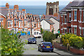
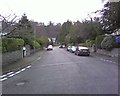
Rhiw Road, Colwyn Bay
Looking down into the town from Rhiw Road (hill or slope in English) with the tower of St Paul's church overlooking the scene.
Image: © Stephen McKay
Taken: 7 Aug 2017
0.10 miles
8
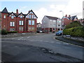
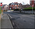
Junction of Woodland Park and Rivieres Avenue, Colwyn Bay
The Woodland Park name sign is on the left.
The Rivieres Avenue name sign is below the hedge on the right.
Image: © Jaggery
Taken: 23 Feb 2016
0.10 miles
9
Empty flats on Coed Pella Road, Colwyn Bay
Image: © colwynboy
Taken: 18 Feb 2009
0.10 miles
10
No Entry signs, Woodland Road East, Colwyn Bay
Facing Woodland Road East at the Woodland Park junction. The car is on the corner of York Road.
Image: © Jaggery
Taken: 23 Feb 2016
0.10 miles