IMAGES TAKEN NEAR TO
Pwllycrochan Avenue, COLWYN BAY, LL29 7DD
Introduction
This page details the photographs taken nearby to Pwllycrochan Avenue, LL29 7DD by members of the Geograph project.
The Geograph project started in 2005 with the aim of publishing, organising and preserving representative images for every square kilometre of Great Britain, Ireland and the Isle of Man.

There are currently over 7.5m images from over14,400 individuals and you can help contribute to the project by visiting https://www.geograph.org.uk
Image Map
Images are licensed for reuse under creativecommons.org/licenses/by-sa/2.0
Notes
- Clicking on the map will re-center to the selected point.
- The higher the marker number, the further away the image location is from the centre of the postcode.
Image Listing (188 Images Found)
Images are licensed for reuse under creativecommons.org/licenses/by-sa/2.0
Image
Details
Distance
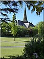
1
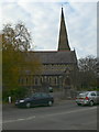
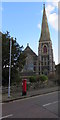
St John's Methodist Church, Colwyn Bay
St John`s Methodist Church is a prominent building on Conway Road and is recognisable by its spire. It was first built in the 19th Century. It is a grade 2 listed building.
Image: © Eirian Evans
Taken: 16 Nov 2007
0.03 miles
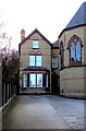
3
Tyn-y-Coed Surgery, Colwyn Bay
Medical surgery at 61 Conway Road, on the corner of Pwllycrochan Avenue.
Image: © Jaggery
Taken: 23 Feb 2016
0.03 miles
4
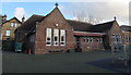
St Joseph's Catholic Primary School, Colwyn Bay
Viewed from Brackley Avenue.
Image: © Jaggery
Taken: 23 Feb 2016
0.04 miles
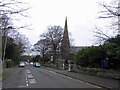
5
Spire of St John's Methodist Church
Spire of St John's Methodist Church viewed from Queen's Gardens.
Image: © Philip Halling
Taken: 26 May 2021
0.04 miles
6
St Joseph's Presbytery, Colwyn Bay
The presbytery (priest's or priests' house) is set back 30 metres from Conway Road,
at the SE corner of the church http://www.geograph.org.uk/photo/5042117 in the Roman Catholic Diocese of Wrexham.
Image: © Jaggery
Taken: 23 Feb 2016
0.04 miles
8
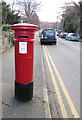
Cipherless pillarbox, Pwllycrochan Avenue, Colwyn Bay
Located here. http://www.geograph.org.uk/photo/5031221 Most UK postboxes have a royal cipher
to indicate the reign in which they were made.
This exception was made by Handyside and Co of Derby & London.
Image: © Jaggery
Taken: 23 Feb 2016
0.05 miles
9
St John's Methodist Church, Colwyn Bay
Erected in 1887-1888, the building was Grade II listed in 1994.
In February 2016, the church name board http://www.geograph.org.uk/photo/5031222 states that there are normally no services here on Sundays.
Image: © Jaggery
Taken: 23 Feb 2016
0.05 miles
10
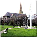
War Memorial and Methodist Church, Colwyn Bay
Both the War Memorial http://www.geograph.org.uk/photo/5031285 and St John's Methodist Church http://www.geograph.org.uk/photo/5031221 are Grade II listed.
Image: © Jaggery
Taken: 23 Feb 2016
0.05 miles