IMAGES TAKEN NEAR TO
Copthorn Mews, COLWYN BAY, LL28 5YZ
Introduction
This page details the photographs taken nearby to Copthorn Mews, LL28 5YZ by members of the Geograph project.
The Geograph project started in 2005 with the aim of publishing, organising and preserving representative images for every square kilometre of Great Britain, Ireland and the Isle of Man.

There are currently over 7.5m images from over14,400 individuals and you can help contribute to the project by visiting https://www.geograph.org.uk
Image Map
Images are licensed for reuse under creativecommons.org/licenses/by-sa/2.0
Notes
- Clicking on the map will re-center to the selected point.
- The higher the marker number, the further away the image location is from the centre of the postcode.
Image Listing (5 Images Found)
Images are licensed for reuse under creativecommons.org/licenses/by-sa/2.0
Image
Details
Distance
1
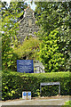
Seion Chapel, Colwyn Heights
Almost hidden in the trees, this chapel on Llanrwst Road was built in 1895 and designed by architects Booth, Chadwick & Porter of Colwyn Bay.
Image: © Stephen McKay
Taken: 7 Aug 2017
0.10 miles
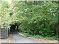
2
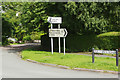
Cherry Tree Lane, Colwyn Heights
Residential street leading off Llanrwst Road.
Image: © Stephen McKay
Taken: 7 Aug 2017
0.11 miles
3
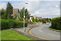
Llanrwst Road, Colwyn Heights
This is looking straight down Llanrwst Road but the B5113 takes a right turn into Pen-y-Bryn Road on its way down into Colwyn Bay town centre.
Image: © Stephen McKay
Taken: 7 Aug 2017
0.15 miles
4
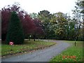
Autumn trees in Colwyn
Tree lined avenue in Upper Colwyn Bay
Image: © Dot Potter
Taken: 29 Oct 2005
0.20 miles
5
The Old Highway
The Old Highway which run above Colwyn Bay
Image: © Dot Potter
Taken: 29 Oct 2005
0.20 miles