IMAGES TAKEN NEAR TO
Ffordd Maenan, COLWYN BAY, LL28 5UG
Introduction
This page details the photographs taken nearby to Ffordd Maenan, LL28 5UG by members of the Geograph project.
The Geograph project started in 2005 with the aim of publishing, organising and preserving representative images for every square kilometre of Great Britain, Ireland and the Isle of Man.

There are currently over 7.5m images from over14,400 individuals and you can help contribute to the project by visiting https://www.geograph.org.uk
Image Map
Images are licensed for reuse under creativecommons.org/licenses/by-sa/2.0
Notes
- Clicking on the map will re-center to the selected point.
- The higher the marker number, the further away the image location is from the centre of the postcode.
Image Listing (5 Images Found)
Images are licensed for reuse under creativecommons.org/licenses/by-sa/2.0
Image
Details
Distance
4
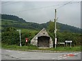
Stone shelter
Stone built bus shelter and post box on the approach to the village of Eglwysbach
Image: © Dot Potter
Taken: 9 Sep 2005
0.23 miles
5
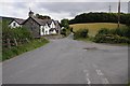
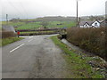
Cottage on a crossroads
Cottage on a crossroads to the south of Eglwysbach.
Image: © Philip Halling
Taken: 16 Aug 2014
0.23 miles