IMAGES TAKEN NEAR TO
Glan Conwy, COLWYN BAY, LL28 5TN
Introduction
This page details the photographs taken nearby to LL28 5TN by members of the Geograph project.
The Geograph project started in 2005 with the aim of publishing, organising and preserving representative images for every square kilometre of Great Britain, Ireland and the Isle of Man.

There are currently over 7.5m images from over14,400 individuals and you can help contribute to the project by visiting https://www.geograph.org.uk
Image Map
Images are licensed for reuse under creativecommons.org/licenses/by-sa/2.0
Notes
- Clicking on the map will re-center to the selected point.
- The higher the marker number, the further away the image location is from the centre of the postcode.
Image Listing (5 Images Found)
Images are licensed for reuse under creativecommons.org/licenses/by-sa/2.0
Image
Details
Distance
1
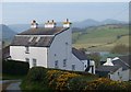
Bryn Trallwyn
Unusually for a traditional farmhouse, this has a monopitch roof.
Image: © Ceri Thomas
Taken: 24 Apr 2010
0.14 miles
2
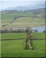
Bryn Trallwyn (2)
This is another image of Image, this time taken from the north, showing the relationship between the house and the outbuildings.
Image: © Ceri Thomas
Taken: 24 Apr 2010
0.14 miles
4
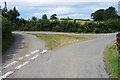
Road Junction at Trallwyn near Glan Conwy
This Junction at Trallwyn is about 2 Kilometres Southwest of Glan Conwy at grid reference SH 79520 74159.
Image: © Terry Hughes
Taken: 1 Aug 2006
0.23 miles