IMAGES TAKEN NEAR TO
Tal-y-Cafn, COLWYN BAY, LL28 5SH
Introduction
This page details the photographs taken nearby to LL28 5SH by members of the Geograph project.
The Geograph project started in 2005 with the aim of publishing, organising and preserving representative images for every square kilometre of Great Britain, Ireland and the Isle of Man.

There are currently over 7.5m images from over14,400 individuals and you can help contribute to the project by visiting https://www.geograph.org.uk
Image Map
Images are licensed for reuse under creativecommons.org/licenses/by-sa/2.0
Notes
- Clicking on the map will re-center to the selected point.
- The higher the marker number, the further away the image location is from the centre of the postcode.
Image Listing (10 Images Found)
Images are licensed for reuse under creativecommons.org/licenses/by-sa/2.0
Image
Details
Distance
1
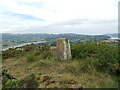
Prenol triangulation pillar, Pentrefelin
This pillar is located on a rocky outcrop overlooking the Conwy valley near Pentrefelin and it is shown in the Ordnance Survey database as being 180.700m above the Newlyn datum. There are some excellent views of the surrounding area from this pillar. See also: Image
Image: © Meirion
Taken: 3 Aug 2011
0.09 miles
2
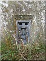
Flush bracket S7341 on the Prenol triangulation pillar, Pentrefelin
See also: Image
Image: © Meirion
Taken: 3 Aug 2011
0.09 miles
3
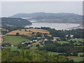
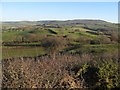
View down the Conwy valley from the Prenol triangulation pillar, Pentrefelin
Image: © Meirion
Taken: 3 Aug 2011
0.09 miles
4
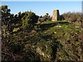
Prenol trig point
This triangulation pillar sits on an isolated hill formed by a prominent rock outcrop, whose slatey beds break surface and are visible in the foreground. There is a minor quarry, long disused, just to the east. Gorse and Blackthorn are threatening to make the summit inaccessible.
Image: © Jonathan Wilkins
Taken: 28 Dec 2014
0.10 miles
5
Hummocky fields
Low light is accentuating the low hummocks whose form is partly controlled by the outcrops of slatey rock beneath a veneer of glacial deposits. It is difficult to be specific without detailed investigation, but many of the hummocks are probably drumlins, whose long axis is aligned with the flow of ice within the Conwy Valley.
Image: © Jonathan Wilkins
Taken: 28 Dec 2014
0.14 miles
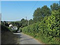
7
Frosty landscape
Bright sun has not cleared the frost from the field with its northerly slope. The distant Carneddau have a fine sprinkle of snow on their summits. It is not obvious where the footpath crosses the field.
Image: © Jonathan Wilkins
Taken: 28 Dec 2014
0.14 miles
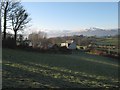
9
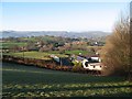
Meusydd Farm
A view down the frosty pasture which slopes away from the sun and has not yet melted. It is not obvious that the A470 trunk road is running through the image, which also shows well the distant, more rugged western side of the Conwy Valley.
Image: © Jonathan Wilkins
Taken: 28 Dec 2014
0.19 miles
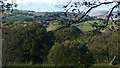
10
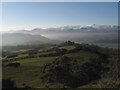
Bodnant view
Looking from Prenol trig point over Bwlch Farm to the wooded lower valley slopes at Bodnant. The distant peaks of the Carneddau are snow-covered and the valley contains a perfect temperature inversion which has trapped overnight mist.
Image: © Jonathan Wilkins
Taken: 28 Dec 2014
0.20 miles