IMAGES TAKEN NEAR TO
Eglwysbach, COLWYN BAY, LL28 5SG
Introduction
This page details the photographs taken nearby to LL28 5SG by members of the Geograph project.
The Geograph project started in 2005 with the aim of publishing, organising and preserving representative images for every square kilometre of Great Britain, Ireland and the Isle of Man.

There are currently over 7.5m images from over14,400 individuals and you can help contribute to the project by visiting https://www.geograph.org.uk
Image Map
Images are licensed for reuse under creativecommons.org/licenses/by-sa/2.0
Notes
- Clicking on the map will re-center to the selected point.
- The higher the marker number, the further away the image location is from the centre of the postcode.
Image Listing (7 Images Found)
Images are licensed for reuse under creativecommons.org/licenses/by-sa/2.0
Image
Details
Distance
1
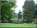
Bodnant Gardens
Bodnant Gardens seen from the top of the car park looking over the tea room roofs.
Image: © Dot Potter
Taken: 9 Sep 2005
0.20 miles
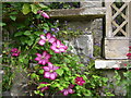
2
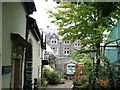
Craft shops at Bodnant Hall
Former outbuildings converted to craft shops with Bodnant Hall seen in the background.
Image: © Dot Potter
Taken: 9 Sep 2005
0.20 miles
4
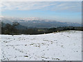
Snowy pasture
The sheep are still nibbling away at the frozen pasture by Cae Forys. The view looks over the Bodnant estate to Tal y Fan in the distance.
Image: © Jonathan Wilkins
Taken: 24 Jan 2013
0.21 miles
5

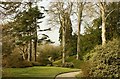
Sheep near Ffordd Bodnant Uchaf
Viewed from the car park for Bodnant Garden.
Image: © Stephen Craven
Taken: 25 May 2017
0.22 miles
7

Bodnant Garden: Overflow car park
A glorious late Spring day, so it was not surprising that the car park at this popular destination was virtually full to capacity.
Image: © Stephen Craven
Taken: 25 May 2017
0.24 miles