IMAGES TAKEN NEAR TO
Cei'r Porthmon, COLWYN BAY, LL28 5RX
Introduction
This page details the photographs taken nearby to Cei'r Porthmon, LL28 5RX by members of the Geograph project.
The Geograph project started in 2005 with the aim of publishing, organising and preserving representative images for every square kilometre of Great Britain, Ireland and the Isle of Man.

There are currently over 7.5m images from over14,400 individuals and you can help contribute to the project by visiting https://www.geograph.org.uk
Image Map
Images are licensed for reuse under creativecommons.org/licenses/by-sa/2.0
Notes
- Clicking on the map will re-center to the selected point.
- The higher the marker number, the further away the image location is from the centre of the postcode.
Image Listing (109 Images Found)
Images are licensed for reuse under creativecommons.org/licenses/by-sa/2.0
Image
Details
Distance
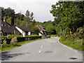
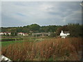
1
Trespassers Will Be Prosecuted
This driveway into a private development is by the side of a track that shares, for part of the way, a public footpath linking the eastern end of the B5279 (behind the viewpoint) with the little church of St Mary, Caer Rhun http://www.churchinwales.org.uk/rb/ben.php?dosommat=detail&which=126 (ahead).
The track can just be made out in the bottom right-hand corner of the image.
Under the lamppost there is a sign that reads Police Notice, Trespassers Will Be Prosecuted.
This photograph was taken on a walk in the Conwy Valley. To join the walk, click here Image
To go to the start of the walk, click here Image
Image: © Alan Walker
Taken: 8 Apr 2007
0.02 miles
3
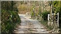
An Easter Walk in the Conwy Valley - 11
This photograph is of the northern end of a footpath that connects the little church of St Mary, Caer Rhun http://www.churchinwales.org.uk/rb/ben.php?dosommat=detail&which=126 (behind the viewpoint) with the eastern end of the B5279 (ahead). The footpath is part of a walk that leads from St Mary, Caer Rhun to Ty’n-y-groes and back via Pontwgan.
From here the walker must turn left (westerly) and walk uphill along the B5279 (watch out for traffic) for some 300metres until another public footpath leading off on the right (north-westerly, from an old section of road) is reached.
To see a photograph looking from the B5279 (ahead) back toward this viewpoint, click here Image
To see the next photograph on this walk, click here Image
To see the previous photograph on the walk, click here Image
To go to the start of the walk, click here Image
Image: © Alan Walker
Taken: 8 Apr 2007
0.03 miles
5
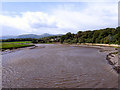
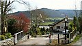
Conwy River
Conwy River, looking upstream from Image
Image: © David Dixon
Taken: 22 May 2011
0.05 miles
6
Afon Conwy
Conway River, looking upstream from Image
Image: © David Dixon
Taken: 22 May 2011
0.05 miles
7
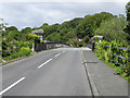
Pont Tal-y-Cafn
The B5279 crossing Tal-y-Cafn Bridge over the Conway River (Afon Conwy).
Image: © David Dixon
Taken: 22 May 2011
0.07 miles
8
The bridge over Afon Conwy at Tal-y-Cafn
This bridge was opened in June 1897.
Image: © Eric Jones
Taken: 26 Oct 2007
0.07 miles
9
Tal-y-Cafn bridge
As viewed from a moving train heading to Llandudno.
Image: © Richard Hoare
Taken: 1 Oct 2011
0.07 miles
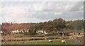
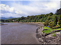
10
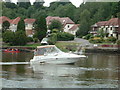
Cruising on the River Conwy at Tal-y-Cafn
The houses in the background and indeed the slipway are on the site of the old Ferry Inn which was sadly demolished many years ago.
Image: © Richard Hoare
Taken: 4 Jul 2004
0.08 miles