IMAGES TAKEN NEAR TO
Tal-y-Cafn, COLWYN BAY, LL28 5RD
Introduction
This page details the photographs taken nearby to LL28 5RD by members of the Geograph project.
The Geograph project started in 2005 with the aim of publishing, organising and preserving representative images for every square kilometre of Great Britain, Ireland and the Isle of Man.

There are currently over 7.5m images from over14,400 individuals and you can help contribute to the project by visiting https://www.geograph.org.uk
Image Map
Images are licensed for reuse under creativecommons.org/licenses/by-sa/2.0
Notes
- Clicking on the map will re-center to the selected point.
- The higher the marker number, the further away the image location is from the centre of the postcode.
Image Listing (9 Images Found)
Images are licensed for reuse under creativecommons.org/licenses/by-sa/2.0
Image
Details
Distance
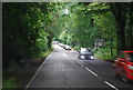
4
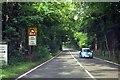
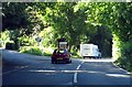
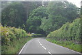
Llanrwst Road to Glan Conwy
The A470, also known as the Cardiff to Glan Conwy Trunk Road, is the major long-distance road in Wales, from Cardiff on the south coast to Llandudno on the north coast.
Image: © Steve Daniels
Taken: 23 Aug 2015
0.10 miles
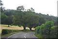
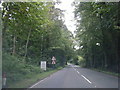
9
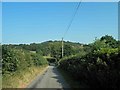
Narrow lane from the A470 near Bodnant
Image: © Steve Fareham
Taken: 18 Jul 2013
0.25 miles