IMAGES TAKEN NEAR TO
Llanrwst Road, COLWYN BAY, LL28 5NR
Introduction
This page details the photographs taken nearby to Llanrwst Road, LL28 5NR by members of the Geograph project.
The Geograph project started in 2005 with the aim of publishing, organising and preserving representative images for every square kilometre of Great Britain, Ireland and the Isle of Man.

There are currently over 7.5m images from over14,400 individuals and you can help contribute to the project by visiting https://www.geograph.org.uk
Image Map
Images are licensed for reuse under creativecommons.org/licenses/by-sa/2.0
Notes
- Clicking on the map will re-center to the selected point.
- The higher the marker number, the further away the image location is from the centre of the postcode.
Image Listing (18 Images Found)
Images are licensed for reuse under creativecommons.org/licenses/by-sa/2.0
Image
Details
Distance
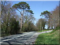
1
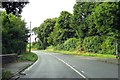
Llanrwst Road heading north through Pentrefelin
The A470, also known as the Cardiff to Glan Conwy Trunk Road, is the major long-distance road in Wales, from Cardiff on the south coast to Llandudno on the north coast.
Image: © Steve Daniels
Taken: 23 Aug 2015
0.06 miles
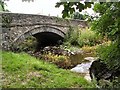
2
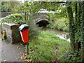
Ffordd Las bridge
Not to mention the dog droppings bin!
Image: © Steve Fareham
Taken: 19 Oct 2010
0.06 miles
4
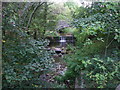
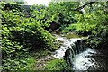
Stream at Ffordd Las
Despite all the recent rain, the stream is a mere trickle to what can be a torrent at times.
Image: © Richard Hoare
Taken: 12 Oct 2011
0.07 miles
5
Fforddlas Bridge and Weir -2020
Taken to replicate the first image submitted to this square in 2006.
Image]
Plenty of vegetation growth sufficient, particularly overhead to make it difficult to find satisfactory lighting conditions
Image: © Richard Hoare
Taken: 9 Sep 2020
0.07 miles
6
Fforddlas Bridge and Weir
A combination of features, adjacent to the A470 Llandudno to Betws-y-Coed road. Behind the viewpoint is the Bus shelter.
Image: © Roger May
Taken: 11 Aug 2005
0.08 miles
7
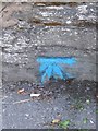
Benchmark on bridge parapet, Pentrefelin
This benchmark is located on the SE parapet of a bridge in Pentrefelin and it is shown in the current Ordnance Survey database at a height of 24.4617m above the Newlyn datum.
Image: © Meirion
Taken: 3 Aug 2011
0.08 miles
8
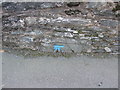
Benchmark at Pentrefelin
Low down on the bridge wall near Nev's Garage.
Image: © Richard Hoare
Taken: 19 Mar 2012
0.08 miles
9
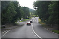
A470 junction of Ffordd Top Llan Glan Conwy
Normally a very busy road from Llanrwst to Glan Conwy and beyond.The junction of the A55 (Black Cat roundabout) is about 1.5 miles north.
Image: © Richard Hoare
Taken: 22 Apr 2010
0.11 miles
10
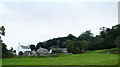
Houses at Ty Isa
This group comprises an original farm house (Ty Isa, the large white building) and three conversions of various ancillary buildings into residential properties, the nearest stone-built one being Ty Cerrig, combining two previous buildings into one house. All are accessed by a private track off Garth Road, and this photo was taken through the only gap in the hedge from a little further north on Garth Road.
Image: © Andy Waddington
Taken: 27 Aug 2020
0.12 miles