IMAGES TAKEN NEAR TO
Tyn Y Celyn, COLWYN BAY, LL28 5NN
Introduction
This page details the photographs taken nearby to Tyn Y Celyn, LL28 5NN by members of the Geograph project.
The Geograph project started in 2005 with the aim of publishing, organising and preserving representative images for every square kilometre of Great Britain, Ireland and the Isle of Man.

There are currently over 7.5m images from over14,400 individuals and you can help contribute to the project by visiting https://www.geograph.org.uk
Image Map
Images are licensed for reuse under creativecommons.org/licenses/by-sa/2.0
Notes
- Clicking on the map will re-center to the selected point.
- The higher the marker number, the further away the image location is from the centre of the postcode.
Image Listing (55 Images Found)
Images are licensed for reuse under creativecommons.org/licenses/by-sa/2.0
Image
Details
Distance
1
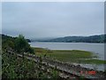
Glan Conwy
View over the railway line to the estuary, Afon Conwy, beyond
Image: © Dot Potter
Taken: 9 Sep 2005
0.08 miles
2
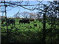
You staring at me? Glan Conwy
Cattle in field off Top Llan Road near Ty Du Road, Glan Conwy.
Image: © Richard Hoare
Taken: 22 Apr 2010
0.08 miles
3
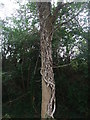
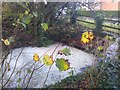
Amazing tree creeper
Note the size of this vine growth. I am told its dead ivy.
Image: © Richard Hoare
Taken: 13 Oct 2011
0.08 miles
4
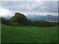
View towards the Carneddau
Tal-y-fan is the most prominent being to the right of the picture. Taken from footpath number 13 above Ty Du farm.
Image: © Richard Hoare
Taken: 13 Oct 2011
0.08 miles
5
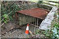
Storm Grid at rest
Compare to Image]
Parking is not allowed.
This stream, one of number that run through and beneath the village is a gentle trickle today. The fact that the grid withholds debris is good news. In 1993 no such grids existed and the lower part of the village was flooded in places.
The grid which spans the stream captures debris washed down from surrounding fields and copses.
Image: © Richard Hoare
Taken: 17 Jan 2016
0.09 miles
6
Storm grid at work
This stream, one of number that run through and beneath the village has been inflated by recent heavy rains.The fact that the grid has withheld debris is good news. In 1993 no such grids existed and the lower part of the village was flooded in places.
The water level here had risen by about 3 - 4 feet above its normal trickle. The grid which spans the stream captures debris washed down from surrounding fields and copses.
Compare to Image]
Image: © Richard Hoare
Taken: 22 Nov 2015
0.09 miles
7
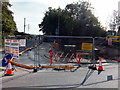
Major works on the culvert at Maes Hyfryd
This culvert has caused a number of issues over past years. As a consequence major works are likely to be in hand for a number of weeks. This restricts access and has curtailed part of the village bus route.
Image: © Richard Hoare
Taken: 20 Sep 2020
0.09 miles
8
Tyn Y Celyn Methodist Chapel - boarded up
A sign of the times. Compare to Image] in 2010.
Image: © Richard Hoare
Taken: 27 Jan 2015
0.10 miles
9
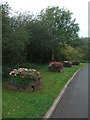
Flower beds Maes Hyfryd
A colourful display despite the autumnal weather. The result of a community project to brighten the village. Created out of old railway sleepers these flower beds have been continually planted this year. Long may it last.
Image: © Richard Hoare
Taken: 13 Oct 2011
0.10 miles
10
A sign of the times
Image] Now it's gone completely!
Image: © Richard Hoare
Taken: 2 May 2023
0.10 miles