IMAGES TAKEN NEAR TO
Ffordd Naddyn, COLWYN BAY, LL28 5NH
Introduction
This page details the photographs taken nearby to Ffordd Naddyn, LL28 5NH by members of the Geograph project.
The Geograph project started in 2005 with the aim of publishing, organising and preserving representative images for every square kilometre of Great Britain, Ireland and the Isle of Man.

There are currently over 7.5m images from over14,400 individuals and you can help contribute to the project by visiting https://www.geograph.org.uk
Image Map
Images are licensed for reuse under creativecommons.org/licenses/by-sa/2.0
Notes
- Clicking on the map will re-center to the selected point.
- The higher the marker number, the further away the image location is from the centre of the postcode.
Image Listing (322 Images Found)
Images are licensed for reuse under creativecommons.org/licenses/by-sa/2.0
Image
Details
Distance
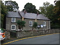
1

Glan Conwy o'r gorllewin / Glan Conwy from the west
Image: © Ceri Thomas
Taken: 27 Dec 2015
0.07 miles
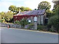
3
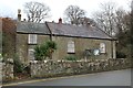
Tyn Y Celyn Methodist Chapel
A year since I last photographed this disused chapel Image
An application has been made for change of use to residential accommodation.
Image: © Richard Hoare
Taken: 24 Jan 2016
0.07 miles
4
Tyn Y Celyn Methodist Chapel - boarded up
A sign of the times. Compare to Image] in 2010.
Image: © Richard Hoare
Taken: 27 Jan 2015
0.08 miles
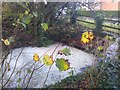
5
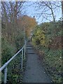
Up a shady leafy alley
Admittedly most are on the ground.
Image: © Richard Hoare
Taken: 8 Dec 2022
0.08 miles
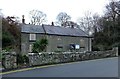
6
Ty'n Y Celyn Welsh Wesleyan Methodist Chapel
Sadly this is falling into disrepair. Compare to 2009 - Image] 2010 - Image] 2015 - Image] 2016 - Image
Coflein states: ''Tyn-y-Celyn Methodist Chapel was built in 1840 in the Vernacular style of the gable entry type. Both the chapel and manse are now Grade 2 Listed buildings for their good external character.''
Any plans to convert seem to have been abandoned.
Image: © Richard Hoare
Taken: 20 Sep 2020
0.09 miles
7
Storm grid at work
This stream, one of number that run through and beneath the village has been inflated by recent heavy rains.The fact that the grid has withheld debris is good news. In 1993 no such grids existed and the lower part of the village was flooded in places.
The water level here had risen by about 3 - 4 feet above its normal trickle. The grid which spans the stream captures debris washed down from surrounding fields and copses.
Compare to Image]
Image: © Richard Hoare
Taken: 22 Nov 2015
0.09 miles
8
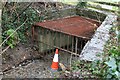
Storm Grid at rest
Compare to Image]
Parking is not allowed.
This stream, one of number that run through and beneath the village is a gentle trickle today. The fact that the grid withholds debris is good news. In 1993 no such grids existed and the lower part of the village was flooded in places.
The grid which spans the stream captures debris washed down from surrounding fields and copses.
Image: © Richard Hoare
Taken: 17 Jan 2016
0.09 miles
9
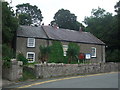
Tyn Y Celyn Methodist Chapel Glan Conwy
Compare to Image taken about 15 months later.
Image: © Richard Hoare
Taken: 10 Aug 2009
0.10 miles
10
Tyn Y Celyn Methodist Chapel Glan Conwy
Compare this with Image - bit of gardening, including pruning of ivy, done and the Yucca's are in bloom. The notice board has also changed.
Image: © Richard Hoare
Taken: 31 Oct 2010
0.10 miles