IMAGES TAKEN NEAR TO
Ffordd Dyffryn, COLWYN BAY, LL28 5DB
Introduction
This page details the photographs taken nearby to Ffordd Dyffryn, LL28 5DB by members of the Geograph project.
The Geograph project started in 2005 with the aim of publishing, organising and preserving representative images for every square kilometre of Great Britain, Ireland and the Isle of Man.

There are currently over 7.5m images from over14,400 individuals and you can help contribute to the project by visiting https://www.geograph.org.uk
Image Map
Images are licensed for reuse under creativecommons.org/licenses/by-sa/2.0
Notes
- Clicking on the map will re-center to the selected point.
- The higher the marker number, the further away the image location is from the centre of the postcode.
Image Listing (16 Images Found)
Images are licensed for reuse under creativecommons.org/licenses/by-sa/2.0
Image
Details
Distance
1
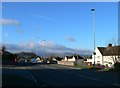
Looking down Conway Road at Mochdre
The road off to the left is Bevan Road.
Image: © Eirian Evans
Taken: 19 Mar 2012
0.08 miles


6
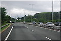
Dwy ffordd i fynd heibio Mochdre / Two ways around Mochdre
The A55 dominates the landscape to such a degree that I did not notice the steam train (Earl of Mount Edgcumbe?) until I downloaded the image.
Image: © Ceri Thomas
Taken: 20 Aug 2012
0.13 miles
8
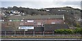
From a Chester-Holyhead train - looking over the A55 towards Mochdre
Image: © Nigel Thompson
Taken: 2 May 2018
0.16 miles
10
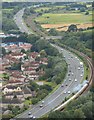
Conway Road
The A547 through Mochdre.
Image: © Gerald England
Taken: 10 Oct 2021
0.19 miles