IMAGES TAKEN NEAR TO
Norton Road, COLWYN BAY, LL28 4TH
Introduction
This page details the photographs taken nearby to Norton Road, LL28 4TH by members of the Geograph project.
The Geograph project started in 2005 with the aim of publishing, organising and preserving representative images for every square kilometre of Great Britain, Ireland and the Isle of Man.

There are currently over 7.5m images from over14,400 individuals and you can help contribute to the project by visiting https://www.geograph.org.uk
Image Map
Images are licensed for reuse under creativecommons.org/licenses/by-sa/2.0
Notes
- Clicking on the map will re-center to the selected point.
- The higher the marker number, the further away the image location is from the centre of the postcode.
Image Listing (21 Images Found)
Images are licensed for reuse under creativecommons.org/licenses/by-sa/2.0
Image
Details
Distance
1

Ordnance Survey Cut Mark
This OS cut mark can be found on the wall of No53 Brompton Avenue. It marks a point 23.042m above mean sea level.
Image: © Adrian Dust
Taken: 14 Sep 2019
0.06 miles
2

Ordnance Survey Cut Mark
This OS cut mark can be found on the wall between Nos63 & 65 Brompton Avenue. It marks a point 26.677m above mean sea level.
Image: © Adrian Dust
Taken: 14 Sep 2019
0.09 miles
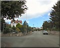
4
Tan-Y-Bryn Road
Horton drive on the left
Image: © Jim Smillie
Taken: 13 May 2022
0.17 miles
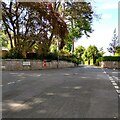
5

Allotments off Tan-Y-Bryn Road
At the access road to footpaths on Bryn Euryn
Image: © Jim Smillie
Taken: 13 May 2022
0.17 miles
6
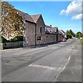
Hanover Court on Rhos Road
What appears to be an old farm steading with the date 1857 is now retirement housing
Image: © Jim Smillie
Taken: 13 May 2022
0.19 miles

8
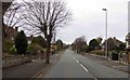
Whitehall Road from Llandudno Road roundabout
Image: © John Firth
Taken: 16 Oct 2019
0.20 miles
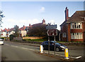
9
Rhos Road Crossroads
At the crossroads with Rhos Road, the B5115 changes from Brompton Avenue into Llandudno Road.
Image: © Gerald England
Taken: 6 Jul 2014
0.20 miles
10

Steps up Bryn Euryn
The main path up the hill from Rhos-on-Sea.
Image: © Stephen Craven
Taken: 22 Jun 2024
0.20 miles