IMAGES TAKEN NEAR TO
The Cloisters, COLWYN BAY, LL28 4PW
Introduction
This page details the photographs taken nearby to The Cloisters, LL28 4PW by members of the Geograph project.
The Geograph project started in 2005 with the aim of publishing, organising and preserving representative images for every square kilometre of Great Britain, Ireland and the Isle of Man.

There are currently over 7.5m images from over14,400 individuals and you can help contribute to the project by visiting https://www.geograph.org.uk
Image Map
Images are licensed for reuse under creativecommons.org/licenses/by-sa/2.0
Notes
- Clicking on the map will re-center to the selected point.
- The higher the marker number, the further away the image location is from the centre of the postcode.
Image Listing (141 Images Found)
Images are licensed for reuse under creativecommons.org/licenses/by-sa/2.0
Image
Details
Distance
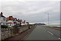
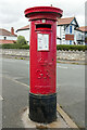
3
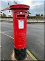
King George V pillar box on Marine Drive, Rhos-on-sea
LL28 53D
Image: © Meirion
Taken: 12 Jan 2023
0.11 miles
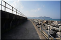
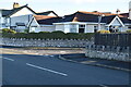
4
Foreshore Park
A closer view of the postbox can be seen here: Image
Image: © Mark Anderson
Taken: 10 Aug 2023
0.11 miles
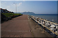
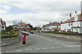
5
George V Postbox, Foreshore Park
Located at the junction with Marine Drive.
Image: © Mark Anderson
Taken: 10 Aug 2023
0.11 miles
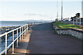
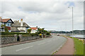
6
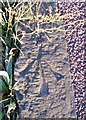
Ordnance Survey Rivet
This OS rivet can be found on a kerb stone NE side of Marine Drive. It marks a point 9.627m above mean sea level.
Image: © Adrian Dust
Taken: 14 Sep 2019
0.11 miles