IMAGES TAKEN NEAR TO
Meadway, COLWYN BAY, LL28 4PG
Introduction
This page details the photographs taken nearby to Meadway, LL28 4PG by members of the Geograph project.
The Geograph project started in 2005 with the aim of publishing, organising and preserving representative images for every square kilometre of Great Britain, Ireland and the Isle of Man.

There are currently over 7.5m images from over14,400 individuals and you can help contribute to the project by visiting https://www.geograph.org.uk
Image Map
Images are licensed for reuse under creativecommons.org/licenses/by-sa/2.0
Notes
- Clicking on the map will re-center to the selected point.
- The higher the marker number, the further away the image location is from the centre of the postcode.
Image Listing (63 Images Found)
Images are licensed for reuse under creativecommons.org/licenses/by-sa/2.0
Image
Details
Distance
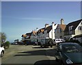
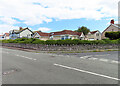
1
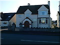
Meadway, Penrhyn Bay
Classic inter-war housing with mock half-timbering.
Image: © Alan Murray-Rust
Taken: 22 Jun 2024
0.01 miles
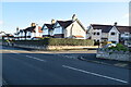
2
1147 Marine Drive - The Old Budget Gate
In 1909 Lloyd George introduced the People's Budget, which started Old Age Pensions, but also included a tax on land values to help pay for them.. This provoked much indignation and opposition from landowners across the UK and a Mr Horton, who owned most of the land in Rhos-on-Sea at the time, put up a toll gate here on the Promenade in protest, and called it The Budget Toll Gate - hence the name of the house.
He sold the road and its tollgate to the tram company in 1911 when they built their new tramway. However the tram company continued to charge a toll to cars using the road, until they became bankrupt in 1961. The toll was only abolished in 1963, when the council bought the road and gave it its first proper surface. Cars were being charged a shilling (5p) and (perambulators a penny) at the time of its closure. (Rhos on Sea Heritage Trail information)
Image: © Eirian Evans
Taken: 14 Jan 2012
0.03 miles
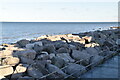
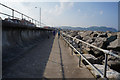
3
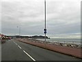
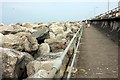
Marine Drive and coastal path Penrhyn Bay/Bae-Penrhyn
Image: © Steve Fareham
Taken: 18 Jan 2016
0.04 miles
5
Greenway, linking Abbey Road & Marine Drive in Rhos on Sea, Colwyn Bay.
Image: © colwynboy
Taken: 8 Apr 2010
0.05 miles
9
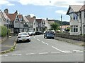
Junction of Marine Drive and Church Drive
Looking across Marine Drive, with Church Drive going off to the right.
Image: © Anne Burgess
Taken: 22 Jun 2024
0.06 miles
10
Ordnance Survey Cut Mark
This OS cut mark can be found on the wall of No89 Marine Drive. It marks a point 8.777m above mean sea level.
Image: © Adrian Dust
Taken: 14 Sep 2019
0.06 miles