IMAGES TAKEN NEAR TO
Marlborough Drive, COLWYN BAY, LL28 4NQ
Introduction
This page details the photographs taken nearby to Marlborough Drive, LL28 4NQ by members of the Geograph project.
The Geograph project started in 2005 with the aim of publishing, organising and preserving representative images for every square kilometre of Great Britain, Ireland and the Isle of Man.

There are currently over 7.5m images from over14,400 individuals and you can help contribute to the project by visiting https://www.geograph.org.uk
Image Map
Images are licensed for reuse under creativecommons.org/licenses/by-sa/2.0
Notes
- Clicking on the map will re-center to the selected point.
- The higher the marker number, the further away the image location is from the centre of the postcode.
Image Listing (62 Images Found)
Images are licensed for reuse under creativecommons.org/licenses/by-sa/2.0
Image
Details
Distance
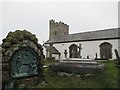
1
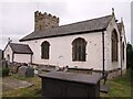
St. Trillo's Church
This is a view from the road looking NNW towards St. Trillo's church at Llandrillo yn Rhos.
Image: © Dave Smethurst
Taken: 20 Sep 2005
0.04 miles
2
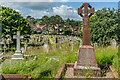
Churchyard, Church of St Trillo
Gravestones in the churchyard of the Church of St Trillo.
Image: © Ian Capper
Taken: 22 Jun 2024
0.05 miles
3
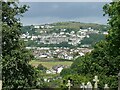
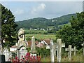
View from the churchyard, Llandrillo-yn-Rhôs
Looking towards Penrhynside and Mynydd Pant.
Image: © Alan Murray-Rust
Taken: 22 Jun 2024
0.05 miles
4
View from the churchyard, Llandrillo-yn-Rhôs
Looking west from the west end of the church.
Image: © Alan Murray-Rust
Taken: 22 Jun 2024
0.05 miles
5
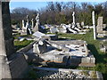
Gravestones in Llandrillo churchyard
Many of the graves have had their crosses and headstones taken down, ostensibly for health and safety reasons. However it does give a desecrated air to this churchyard.
Image: © Eirian Evans
Taken: 5 Mar 2010
0.05 miles
6
St Trillo's Church, Llandrillo-yn-Rhos
Image: © Chris Andrews
Taken: 15 Jul 2021
0.06 miles
7
Cut benchmark, St Trillo's Church, Llandrillo-yn-Rhôs
On the south-west corner of the tower.
Image: © Alan Murray-Rust
Taken: 22 Jun 2024
0.06 miles
8
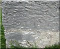
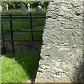
Ordnance Survey Cut Mark
This OS cut mark can be found on the south face of the Church. It marks a point 37.876m above mean sea level.
Image: © Adrian Dust
Taken: 21 Jun 2016
0.06 miles
9
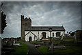
The Parish Church of Llandrillo yn Rhos
Image: © Brian Deegan
Taken: 8 Oct 2016
0.06 miles