IMAGES TAKEN NEAR TO
Llandudno Road, COLWYN BAY, LL28 4EX
Introduction
This page details the photographs taken nearby to Llandudno Road, LL28 4EX by members of the Geograph project.
The Geograph project started in 2005 with the aim of publishing, organising and preserving representative images for every square kilometre of Great Britain, Ireland and the Isle of Man.

There are currently over 7.5m images from over14,400 individuals and you can help contribute to the project by visiting https://www.geograph.org.uk
Image Map
Images are licensed for reuse under creativecommons.org/licenses/by-sa/2.0
Notes
- Clicking on the map will re-center to the selected point.
- The higher the marker number, the further away the image location is from the centre of the postcode.
Image Listing (66 Images Found)
Images are licensed for reuse under creativecommons.org/licenses/by-sa/2.0
Image
Details
Distance
1
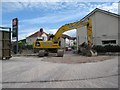
Farewell, Geordie's Garage
Sudden closure of the shop and petrol station on the corner of Dinerth Road surprised many people, including me. Within days the canopy and storage tanks had gone, although the Texaco sign was still in place. It has been announced that the Co-operative group has plans to expand the store and grow its convenience business. Two other Co-operative stores are already situated nearby at Rhos-on-Sea and Penrhyn Bay.
Image: © Jonathan Wilkins
Taken: 18 Jun 2015
0.02 miles
2
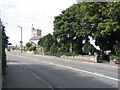
St. Trillo's Church
This is a view from the road looking NNW towards St. Trillo's church at Llandrillo yn Rhos.
Image: © Dave Smethurst
Taken: 20 Sep 2005
0.06 miles
3
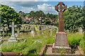
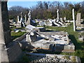
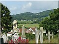
Churchyard, Church of St Trillo
Gravestones in the churchyard of the Church of St Trillo.
Image: © Ian Capper
Taken: 22 Jun 2024
0.09 miles
4
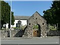
Lychgate, St Trillo's Church, Llandrillo-yn-Rhôs
Built in 1677 https://www.geograph.org.uk/photo/7811864 , restored 1907. Listed Grade II.
Image: © Alan Murray-Rust
Taken: 22 Jun 2024
0.10 miles
5
Gravestones in Llandrillo churchyard
Many of the graves have had their crosses and headstones taken down, ostensibly for health and safety reasons. However it does give a desecrated air to this churchyard.
Image: © Eirian Evans
Taken: 5 Mar 2010
0.10 miles
6
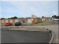
Government Offices, Dinerth Road
The Government Offices in Dinerth Road obviously have a long history, and it is my impression that they date back to the years of World War II, based upon their flat-roofed, utilitarian aspect. They are now used by various companies and Conwy County Borough Council, although the Welsh Government has withdrawn from the site since completion of their new building which amalgamated a number of local outposts Image
Image: © Jonathan Wilkins
Taken: 18 Jun 2015
0.10 miles
7
Cut benchmark, St Trillo's Church, Llandrillo-yn-Rhôs
On the south-west corner of the tower.
Image: © Alan Murray-Rust
Taken: 22 Jun 2024
0.11 miles
8
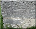
Ordnance Survey Cut Mark
This OS cut mark can be found on the south face of the Church. It marks a point 37.876m above mean sea level.
Image: © Adrian Dust
Taken: 21 Jun 2016
0.11 miles
9
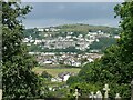
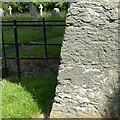
View from the churchyard, Llandrillo-yn-Rhôs
Looking towards Penrhynside and Mynydd Pant.
Image: © Alan Murray-Rust
Taken: 22 Jun 2024
0.11 miles
10
View from the churchyard, Llandrillo-yn-Rhôs
Looking west from the west end of the church.
Image: © Alan Murray-Rust
Taken: 22 Jun 2024
0.11 miles