IMAGES TAKEN NEAR TO
Cysgod Y Bryn, COLWYN BAY, LL28 4EW
Introduction
This page details the photographs taken nearby to Cysgod Y Bryn, LL28 4EW by members of the Geograph project.
The Geograph project started in 2005 with the aim of publishing, organising and preserving representative images for every square kilometre of Great Britain, Ireland and the Isle of Man.

There are currently over 7.5m images from over14,400 individuals and you can help contribute to the project by visiting https://www.geograph.org.uk
Image Map
Images are licensed for reuse under creativecommons.org/licenses/by-sa/2.0
Notes
- Clicking on the map will re-center to the selected point.
- The higher the marker number, the further away the image location is from the centre of the postcode.
Image Listing (62 Images Found)
Images are licensed for reuse under creativecommons.org/licenses/by-sa/2.0
Image
Details
Distance
1

Former Penrhyn Sewage Pumping Station – 3
View with the former boiler house to the right.
Image: © Alan Murray-Rust
Taken: 22 Jun 2024
0.06 miles
2
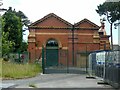
Former Penrhyn Sewage Pumping Station – 1
Early 20th century, brick and buff terracotta, now converted into a fitness centre. Listed Grade II.
Image: © Alan Murray-Rust
Taken: 22 Jun 2024
0.07 miles
3

Former Penrhyn Sewage Pumping Station – 2
Detail of the terracotta decoration. See https://www.geograph.org.uk/photo/7811902 for location
Image: © Alan Murray-Rust
Taken: 22 Jun 2024
0.07 miles
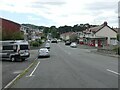
4
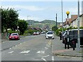
Penrhyn Road, Llandrillo-yn-Rhôs
Looking towards Penrhyn Bay and the Little Orme.
This was the route of the Llandudno and Colwyn Bay Electric Railway, a tramway between those two towns which ran until 1956. The roadway on the left is where the tramway depot was situated.
Image: © Alan Murray-Rust
Taken: 22 Jun 2024
0.07 miles
5

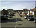
Church Road, Rhôs-on-Sea
View from Elwy Road. The reverse of https://www.geograph.org.uk/photo/7811934
Image: © Alan Murray-Rust
Taken: 22 Jun 2024
0.09 miles
7
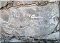
Ordnance Survey Cut Mark
This OS cut mark can be found on the wall of No5 Church Road. It marks a point 4.192m above mean sea level.
Image: © Adrian Dust
Taken: 14 Sep 2019
0.10 miles
8
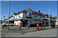
Rhos on Sea Stores
Showing position of Postbox No. LL28 48.
See Image] for postbox.
Image: © JThomas
Taken: 15 Apr 2024
0.10 miles
9
Church Road, Llandrillo-yn-Rhôs
View from Abbey Drive. The reverse of https://www.geograph.org.uk/photo/7811899
Image: © Alan Murray-Rust
Taken: 22 Jun 2024
0.11 miles
10
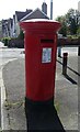
George V postbox on Penrhyn Avenue, Rhos-on-Sea
Postbox No. LL28 48.
See Image] for context.
Image: © JThomas
Taken: 15 Apr 2024
0.11 miles