IMAGES TAKEN NEAR TO
Kenelm Road, COLWYN BAY, LL28 4EE
Introduction
This page details the photographs taken nearby to Kenelm Road, LL28 4EE by members of the Geograph project.
The Geograph project started in 2005 with the aim of publishing, organising and preserving representative images for every square kilometre of Great Britain, Ireland and the Isle of Man.

There are currently over 7.5m images from over14,400 individuals and you can help contribute to the project by visiting https://www.geograph.org.uk
Image Map
Images are licensed for reuse under creativecommons.org/licenses/by-sa/2.0
Notes
- Clicking on the map will re-center to the selected point.
- The higher the marker number, the further away the image location is from the centre of the postcode.
Image Listing (79 Images Found)
Images are licensed for reuse under creativecommons.org/licenses/by-sa/2.0
Image
Details
Distance
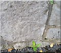
1
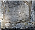
Ordnance Survey Cut Mark
This OS cut mark can be found on the wall north side of Llannerch Road East. It marks a point 18.610m above mean sea level.
Image: © Adrian Dust
Taken: 14 Sep 2019
0.09 miles
2
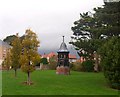
Cupola Coleg Penrhos / Penrhos College Cupola
The cupola was salvaged from the old school when the site was redeveloped.
Image: © Ceri Thomas
Taken: 21 Nov 2009
0.11 miles
4
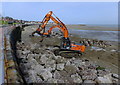
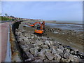
Sea defence work at Colwyn Bay (1)
Following the devastating storms of the past winter work has commenced on strengthening the sea wall defences along the coast at Colwyn Bay.
This Hitachi Zaxis 350 LC and its counterpart were lifting huge boulders which have been dumped on the beach and placing them against the existing sea walls with the view to their breaking the waves as they roll in.
Image: © Richard Hoare
Taken: 25 Mar 2014
0.12 miles
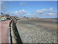
5
Sea defence work at Colwyn Bay (2)
Following the devastating storms of the past winter work has commenced on strengthening the sea wall defences along the coast at Colwyn Bay.
This Hitachi Zaxis 350 LC and its counterpart were lifting huge boulders which have been dumped on the beach and placing them against the existing sea walls with the view to their breaking the waves as they roll in.
Image: © Richard Hoare
Taken: 25 Mar 2014
0.12 miles
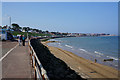
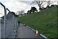
7
Foreshore facing Rhos on Sea
Bright but with a chilly wind.
Image: © Richard Hoare
Taken: 12 Apr 2012
0.12 miles
8
30 m.p.h. or knots
Dinghy being transferred to a nearby slipway. Image]
Image: © Richard Hoare
Taken: 12 Oct 2016
0.12 miles
10
Ordnance Survey Cut Mark
This OS cut mark can be found on the wall east side of Brompton Avenue. It marks a point 19.990m above mean sea level.
Image: © Adrian Dust
Taken: 14 Sep 2019
0.13 miles