IMAGES TAKEN NEAR TO
Kenelm Road, COLWYN BAY, LL28 4ED
Introduction
This page details the photographs taken nearby to Kenelm Road, LL28 4ED by members of the Geograph project.
The Geograph project started in 2005 with the aim of publishing, organising and preserving representative images for every square kilometre of Great Britain, Ireland and the Isle of Man.

There are currently over 7.5m images from over14,400 individuals and you can help contribute to the project by visiting https://www.geograph.org.uk
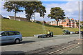
Image Map
Images are licensed for reuse under creativecommons.org/licenses/by-sa/2.0
Notes
- Clicking on the map will re-center to the selected point.
- The higher the marker number, the further away the image location is from the centre of the postcode.
Image Listing (68 Images Found)
Images are licensed for reuse under creativecommons.org/licenses/by-sa/2.0
Image
Details
Distance
3
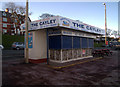
The Cayley kiosk
Closed for the winter. Even the seagulls had departed - for once.
Image: © Richard Hoare
Taken: 21 Nov 2012
0.12 miles
4
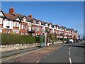
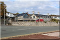
Whitehall Road
An elegant terrace alongside Whitehall Road as it approaches the Cayley Promenade in Rhos-on-Sea. These houses date from the late-Victorian to Edwardian seaside building boom and appear between the OS map 1888 and 1911 revisions.
Image: © Jonathan Wilkins
Taken: 3 Mar 2020
0.12 miles
5
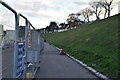
30 m.p.h. or knots
Dinghy being transferred to a nearby slipway. Image]
Image: © Richard Hoare
Taken: 12 Oct 2016
0.13 miles
6
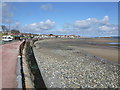
Strollers enjoying the winter sun at Llandrillo yn Rhos
Image: © Eirian Evans
Taken: 14 Jan 2012
0.13 miles
7
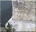
Ordnance Survey Cut Mark
This OS cut mark can be found on the gatepost of Cliffe House, St Georges Road. It marks a point 15.660m above mean sea level.
Image: © Adrian Dust
Taken: 14 Sep 2019
0.13 miles
8
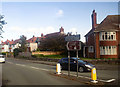
Whitehall Road from Llandudno Road roundabout
Image: © John Firth
Taken: 16 Oct 2019
0.13 miles
9
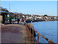
Foreshore facing Rhos on Sea
Bright but with a chilly wind.
Image: © Richard Hoare
Taken: 12 Apr 2012
0.14 miles
10
The ongoing saga of the Aberhod Hall
Built in 1763, surprisingly this building was not listed.
In 2011 plans were submitted to convert the former manor house and more recently a restaurant building into six homes. These were rejected. However they were approved on appeal in January 2012 in spite of considerable objections from local councillors.
Since then there has been spasmodic amounts of work carried out resulting in today's findings.
Image: © Richard Hoare
Taken: 12 Oct 2016
0.15 miles