IMAGES TAKEN NEAR TO
First Avenue, COLWYN BAY, LL28 4DQ
Introduction
This page details the photographs taken nearby to First Avenue, LL28 4DQ by members of the Geograph project.
The Geograph project started in 2005 with the aim of publishing, organising and preserving representative images for every square kilometre of Great Britain, Ireland and the Isle of Man.

There are currently over 7.5m images from over14,400 individuals and you can help contribute to the project by visiting https://www.geograph.org.uk
Image Map
Images are licensed for reuse under creativecommons.org/licenses/by-sa/2.0
Notes
- Clicking on the map will re-center to the selected point.
- The higher the marker number, the further away the image location is from the centre of the postcode.
Image Listing (76 Images Found)
Images are licensed for reuse under creativecommons.org/licenses/by-sa/2.0
Image
Details
Distance
1
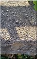
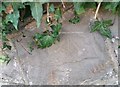
Ordnance Survey Rivet
This OS rivet can be found on the wall SE side of Church Road. It marks a point 14.291m above mean sea level.
Image: © Adrian Dust
Taken: 14 Sep 2019
0.09 miles
2
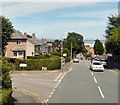
Church Road
At the junction with First Avenue.
Image: © Gerald England
Taken: 10 Jul 2014
0.09 miles
3
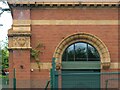
Former Penrhyn Sewage Pumping Station – 2
Detail of the terracotta decoration. See https://www.geograph.org.uk/photo/7811902 for location
Image: © Alan Murray-Rust
Taken: 22 Jun 2024
0.09 miles
4
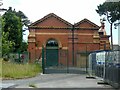
Former Penrhyn Sewage Pumping Station – 1
Early 20th century, brick and buff terracotta, now converted into a fitness centre. Listed Grade II.
Image: © Alan Murray-Rust
Taken: 22 Jun 2024
0.09 miles
5
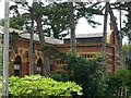
Former Penrhyn Sewage Pumping Station – 3
View with the former boiler house to the right.
Image: © Alan Murray-Rust
Taken: 22 Jun 2024
0.09 miles
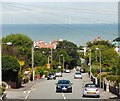
6
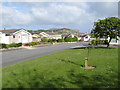
Malvern Rise
Looking from the green space enclosed by the loop of Malvern Rise toward the Little Orme.
Image: © Jonathan Wilkins
Taken: 24 May 2011
0.10 miles
7
Ordnance Survey Cut Mark
This OS cut mark can be found on the wall of Rock Bank, Church Road. It marks a point 21.198m above mean sea level.
Image: © Adrian Dust
Taken: 14 Sep 2019
0.10 miles
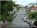
8
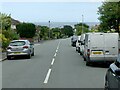
Church Road, Llandrillo-yn-Rhôs
Looking north from Bryn Eglwys.
Image: © Alan Murray-Rust
Taken: 22 Jun 2024
0.12 miles
10
Church Road, Rhôs-on-Sea
View from Elwy Road. The reverse of https://www.geograph.org.uk/photo/7811934
Image: © Alan Murray-Rust
Taken: 22 Jun 2024
0.14 miles