IMAGES TAKEN NEAR TO
Penrhos Road, COLWYN BAY, LL28 4DB
Introduction
This page details the photographs taken nearby to Penrhos Road, LL28 4DB by members of the Geograph project.
The Geograph project started in 2005 with the aim of publishing, organising and preserving representative images for every square kilometre of Great Britain, Ireland and the Isle of Man.

There are currently over 7.5m images from over14,400 individuals and you can help contribute to the project by visiting https://www.geograph.org.uk
Image Map
Images are licensed for reuse under creativecommons.org/licenses/by-sa/2.0
Notes
- Clicking on the map will re-center to the selected point.
- The higher the marker number, the further away the image location is from the centre of the postcode.
Image Listing (156 Images Found)
Images are licensed for reuse under creativecommons.org/licenses/by-sa/2.0
Image
Details
Distance
2
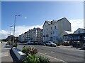
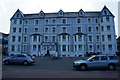
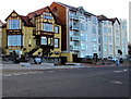
Hotel Rothsay, Colwyn Bay
Large hotel on the promenade in Colwyn Bay.
Image: © Eirian Evans
Taken: 14 Jan 2012
0.03 miles
3
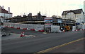
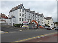
Ocean View construction site, Colwyn Bay
The corner of Sea Bank Road and West Promenade viewed in late February 2016.
A block of apartments named Ocean View is being built on the site of the demolished Hotel Rothesay.
Image: © Jaggery
Taken: 23 Feb 2016
0.04 miles
4
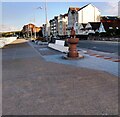
West Promenade: Colwyn Bay
With what was possibly a drinking fountain
Image: © Jim Smillie
Taken: 11 May 2022
0.04 miles
7
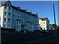
Hotel Rothesay 2015
Moved on a bit since Image] in 2013. Currently in the process of being turned into luxury apartments.
However the past history was:-
The building was constructed as an hotel at around the close of the 19th century. It was one of a string of prestigious hotels along this stretch of the promenade. Its size gives you a vivid illustration of the thriving holiday business which Colwyn Bay once attracted. Today the building is given over to flat accommodation and the Daffodil Day Care Centre.
In 1939 the hotel was taken over by the Ministry of Food and remained in their hands for the duration of the Second World War. Part of the hotel was given over to the Canned Condensed Milk Division.
Mr Lyons of the London Corner Houses was in charge. Oddly, the Prime Minister of the Netherlands came to visit the workers during the war. The Ministry officials in the Rothesay were envied for their proximity to the promenade, where they could go for a stroll during their lunch break. However, they were not allowed to venture onto the beach – which was out of bounds to everyone except military personnel.
With thanks to Graham Roberts, of Colwyn Bay Civic Society, for the above.
Image: © Richard Hoare
Taken: 25 Jun 2015
0.05 miles
9
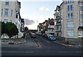
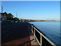
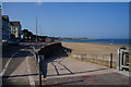
West Promenade, Colwyn Bay
West Promenade from the Toad http://www.geograph.org.uk/photo/4839608 on the corner of Marine Road on the left,
to the corner of Sea Bank Road beyond the multi-storey apartments on the right.
Image: © Jaggery
Taken: 23 Feb 2016
0.05 miles