IMAGES TAKEN NEAR TO
Penmaen Court, COLWYN BAY, LL28 4AN
Introduction
This page details the photographs taken nearby to Penmaen Court, LL28 4AN by members of the Geograph project.
The Geograph project started in 2005 with the aim of publishing, organising and preserving representative images for every square kilometre of Great Britain, Ireland and the Isle of Man.

There are currently over 7.5m images from over14,400 individuals and you can help contribute to the project by visiting https://www.geograph.org.uk
Image Map
Images are licensed for reuse under creativecommons.org/licenses/by-sa/2.0
Notes
- Clicking on the map will re-center to the selected point.
- The higher the marker number, the further away the image location is from the centre of the postcode.
Image Listing (51 Images Found)
Images are licensed for reuse under creativecommons.org/licenses/by-sa/2.0
Image
Details
Distance
1
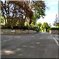
Tan-Y-Bryn Road
Horton drive on the left
Image: © Jim Smillie
Taken: 13 May 2022
0.06 miles
2

Rockface on the path around Bryn Euryn
Some of the limestone strata forming the hill can be seen in this outcrop.
Image: © Stephen Craven
Taken: 22 Jun 2024
0.10 miles
3
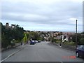
Gregory Avenue
Gregory Avenue in Colwyn Bay looking down over the roof tops towards the sea
Image: © Dot Potter
Taken: 8 Sep 2005
0.12 miles
4
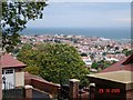
View over Colwyn Bay
Taken from The Old Highway above Colwyn Bay looking over the rooftops of the town out to the coast.
Image: © Dot Potter
Taken: 29 Oct 2005
0.12 miles
6
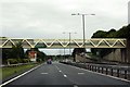
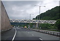
Footbridge over the North Wales Expressway
The footbridge links Tan-Y-Bryn Road to Conway Road.
Image: © Steve Daniels
Taken: 23 Aug 2015
0.13 miles
7
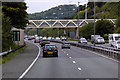
Footbridge over the A55 near Llandrillo-yn-Rh?s
Image: © David Dixon
Taken: 24 Sep 2017
0.13 miles
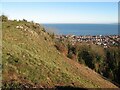
8

Bryn Euryn
Limestone grassland below the top of Bryn Euryn with Rhos-on-Sea in the background.
Image: © Ian Capper
Taken: 22 Jun 2024
0.13 miles
9
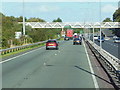
A55 North Wales Expressway towards junction 20
Image: © Ian S
Taken: 28 Aug 2014
0.13 miles
10
Cleared scrub
Clearance of scrub is part of the management of the nature reserve because grazing animals are not part of the local plan. The work to improve biodiversity through reducing scrub and introduced invasive species will help restore rare limestone grassland on this SSSI facilitated by the Nature Networks Fund.
Image: © Jonathan Wilkins
Taken: 12 Dec 2022
0.14 miles