IMAGES TAKEN NEAR TO
TREFRIW, LL27 0UQ
Introduction
This page details the photographs taken nearby to LL27 0UQ by members of the Geograph project.
The Geograph project started in 2005 with the aim of publishing, organising and preserving representative images for every square kilometre of Great Britain, Ireland and the Isle of Man.

There are currently over 7.5m images from over14,400 individuals and you can help contribute to the project by visiting https://www.geograph.org.uk
Image Map
Images are licensed for reuse under creativecommons.org/licenses/by-sa/2.0
Notes
- Clicking on the map will re-center to the selected point.
- The higher the marker number, the further away the image location is from the centre of the postcode.
Image Listing (153 Images Found)
Images are licensed for reuse under creativecommons.org/licenses/by-sa/2.0
Image
Details
Distance
1
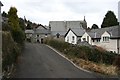
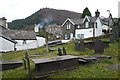
Back street in Trefriw
A narrow no through road in Trefriw village. The large building in the background is the Peniel Chapel (Calvinist Methodist).
Image: © Dave Dunford
Taken: 24 Feb 2013
0.01 miles
2

Peniel Calvinistic Methodist chapel
The old Peniel chapel (up School Bank Road) was built in Victorian times but closed in August 1910 when it became too small for its congregation. Peniel Calvinistic Methodist chapel was built in 1909. The original plans show that it was intended to have a spire and would have been even more imposing. The new Peniel Chapel seated 550 people, with an attached schoolroom capable of holding 225 more. It was designed by a company from Shrewsbury, and is somewhat reminiscent of a late-Gothic style. Its organ was water-powered.
Image
Image: © Gerald England
Taken: 27 May 2015
0.01 miles
3
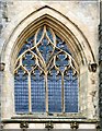
Peniel chapel: Window detail
The main window in Peniel chapel Image
Image: © Gerald England
Taken: 27 May 2015
0.01 miles
4
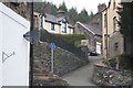
Narrow road in Trefriw
No through road between the Peniel Chapel (to the left) and the churchyard of St Mary's Church (right) in Trefriw.
Image: © Dave Dunford
Taken: 24 Feb 2013
0.02 miles
5
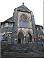
Peniel Chapel, Trefriw
The view of the Calvinistic Methodist chapel from the foot of the steps.
Image: © Karen Chantrey Wood
Taken: 9 Aug 2009
0.02 miles
6
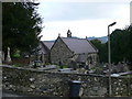
Trefriw from the churchyard
Looking over the typical Welsh slate gravestones to the village of Trefriw and the wooded hillside of Coed y wern beyond.
Image: © Dave Dunford
Taken: 24 Feb 2013
0.02 miles
7
St Mary's Church, Trefriw
A church was built here about 1230 by Llewelyn ap Iorwerth as a chapel of ease for his wife, Joan, who was the daughter of England's King John. The church was entirely remodelled in the 15th, 16th and 19th Centuries and no part of the original church now remains except possibly part of the wall of the south aisle.
Image: © Eirian Evans
Taken: 20 Nov 2007
0.02 miles
8
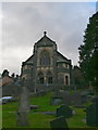
Peniel, Trefriw
This is a Grade II listed building, standing in an imposing site overlooking Trefriw. It is a Welsh Presbyterian Chapel, raised up on a revetted and railed terrace with simple gates and gatepiers.
Image: © Eirian Evans
Taken: 20 Nov 2007
0.02 miles
9
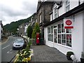
Trefriw: the post office
The post office occupies a central position in the village, on the main B5106.
Image: © Chris Downer
Taken: 11 Aug 2013
0.02 miles
10
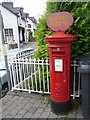
Trefriw: postbox № LL27 41
This Elizabeth II-reign postbox stands outside Image and has on top a post office direction sign, written in Welsh.
Image: © Chris Downer
Taken: 11 Aug 2013
0.02 miles