IMAGES TAKEN NEAR TO
Maes Bodaelog, TREFRIW, LL27 0QD
Introduction
This page details the photographs taken nearby to Maes Bodaelog, LL27 0QD by members of the Geograph project.
The Geograph project started in 2005 with the aim of publishing, organising and preserving representative images for every square kilometre of Great Britain, Ireland and the Isle of Man.

There are currently over 7.5m images from over14,400 individuals and you can help contribute to the project by visiting https://www.geograph.org.uk
Image Map
Images are licensed for reuse under creativecommons.org/licenses/by-sa/2.0
Notes
- Clicking on the map will re-center to the selected point.
- The higher the marker number, the further away the image location is from the centre of the postcode.
Image Listing (151 Images Found)
Images are licensed for reuse under creativecommons.org/licenses/by-sa/2.0
Image
Details
Distance
1
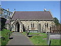
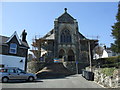
Entrance and path to St Mary's Church Trefriw
The pathway seems to include a number of very worn gravestones.Image]
The east end contains an OS flush bracket.
Image]
Image: © Richard Hoare
Taken: 28 Mar 2012
0.03 miles
2
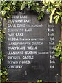
All gardeners are entitled to a rest
An entry for Trefriw's scarecrow competition to be judged July 13 2017.
Image: © Richard Hoare
Taken: 24 Jun 2017
0.03 miles
3

Scarecrow butcher
An entry for Trefriw's scarecrow competition to be judged July 13 2017.
Image: © Richard Hoare
Taken: 24 Jun 2017
0.03 miles
4
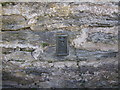
Flush bracket at St Mary's Church Trefriw
OS benchmark - flush bracket - S7461.Image]
Image: © Richard Hoare
Taken: 28 Mar 2012
0.03 miles
5
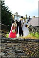
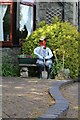
The happy couple and bridesmaid
An entry for Trefriw's scarecrow competition to be judged July 13 2017.
Image: © Richard Hoare
Taken: 24 Jun 2017
0.03 miles
6
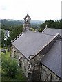
St Mary's church, Trefriw
The view of the back of the 12th century church taken from Victoria Terrace. A view familiar to my Great-grandparents who lived in the terrace, and apart from the new roof, remarkably unchanged.
Image: © Karen Chantrey Wood
Taken: 9 Aug 2009
0.03 miles
7
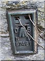
Ordnance Survey Flush Bracket (S7461)
This OS Flush Bracket can be found on the east face of St Mary's Church. It marks a point 14.940m above mean sea level.
Image: © Adrian Dust
Taken: 27 Oct 2018
0.04 miles
8
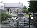
Entrance to St Mary's church, Trefriw
Looking through the entrance gates to the medieval church.
Image: © Karen Chantrey Wood
Taken: 9 Aug 2009
0.04 miles
9
Peniel Calvinistic Methodist Chapel Trefriw
Chapel built in 1909 and currently undergoing refurbishment works.
Image: © Richard Hoare
Taken: 28 Mar 2012
0.04 miles