IMAGES TAKEN NEAR TO
DOLWYDDELAN, LL25 0PZ
Introduction
This page details the photographs taken nearby to LL25 0PZ by members of the Geograph project.
The Geograph project started in 2005 with the aim of publishing, organising and preserving representative images for every square kilometre of Great Britain, Ireland and the Isle of Man.

There are currently over 7.5m images from over14,400 individuals and you can help contribute to the project by visiting https://www.geograph.org.uk
Image Map
Images are licensed for reuse under creativecommons.org/licenses/by-sa/2.0
Notes
- Clicking on the map will re-center to the selected point.
- The higher the marker number, the further away the image location is from the centre of the postcode.
Image Listing (28 Images Found)
Images are licensed for reuse under creativecommons.org/licenses/by-sa/2.0
Image
Details
Distance
3
Unclassified road above the junction of Afonydd Lledr & Conwy
Image: © David Medcalf
Taken: 20 May 2006
0.01 miles
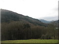
5
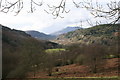
Lledr Valley and Moel Siabod
As seen from the lay-by on the A5 above the Fairy Glen.
Image: © Chris Denny
Taken: 18 Feb 2006
0.13 miles
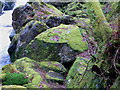
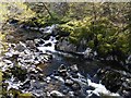
7
Afon Conwy
Ravine on the River Conwy near the Fairy Glen.
Image: © Eirian Evans
Taken: 21 Jan 2009
0.13 miles
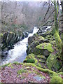
9
Afon Conwy below the Fairy Glen
The narrowest part of the gorge is upstream from here. A little further downstream the river is joined by the Lledr at Tyn y Cae Pool.
Image: © Phil Champion
Taken: 18 Apr 2009
0.18 miles
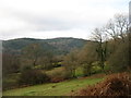
10
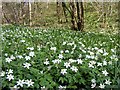
Wood anemones and hazel coppice beside the Afon Conwy
Image: © Phil Champion
Taken: 18 Apr 2009
0.20 miles