IMAGES TAKEN NEAR TO
DOLWYDDELAN, LL25 0HQ
Introduction
This page details the photographs taken nearby to LL25 0HQ by members of the Geograph project.
The Geograph project started in 2005 with the aim of publishing, organising and preserving representative images for every square kilometre of Great Britain, Ireland and the Isle of Man.

There are currently over 7.5m images from over14,400 individuals and you can help contribute to the project by visiting https://www.geograph.org.uk
Image Map
Images are licensed for reuse under creativecommons.org/licenses/by-sa/2.0
Notes
- Clicking on the map will re-center to the selected point.
- The higher the marker number, the further away the image location is from the centre of the postcode.
Image Listing (8 Images Found)
Images are licensed for reuse under creativecommons.org/licenses/by-sa/2.0
Image
Details
Distance
1
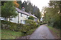
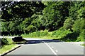
Cottages
Cottages on minor road near to Betws-y-Coed, Conwy.
Image: © Keith Evans
Taken: 12 Oct 2014
0.01 miles
3
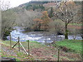
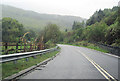
Afon Lledr
The Lledr has its source on the eastern slopes of Ysgafell Wen, which lies between Moel Siabod and Cnicht. It flows along the Lledr Valley, running parallel to the A470 and the railway line from Blaenau Ffestiniog to Llandudno. The river joins the River Conwy to the south of Betws-y-Coed.
Image: © Eirian Evans
Taken: 4 Nov 2009
0.13 miles
5
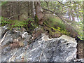
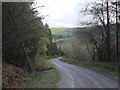
Quartz intrusions in slate under pine forest at Clogwyn Brith
Image: © Gary Rogers
Taken: 15 Apr 2017
0.18 miles
7
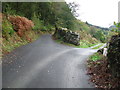
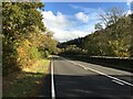
Farm Entrance
Farm entrance of Ty'n y Berth off minor road near to Penmachno, Conwy.
Image: © Keith Evans
Taken: 13 Oct 2014
0.20 miles