IMAGES TAKEN NEAR TO
Pentrefoelas, BETWS-Y-COED, LL24 0TR
Introduction
This page details the photographs taken nearby to LL24 0TR by members of the Geograph project.
The Geograph project started in 2005 with the aim of publishing, organising and preserving representative images for every square kilometre of Great Britain, Ireland and the Isle of Man.

There are currently over 7.5m images from over14,400 individuals and you can help contribute to the project by visiting https://www.geograph.org.uk
Image Map
Images are licensed for reuse under creativecommons.org/licenses/by-sa/2.0
Notes
- Clicking on the map will re-center to the selected point.
- The higher the marker number, the further away the image location is from the centre of the postcode.
Image Listing (11 Images Found)
Images are licensed for reuse under creativecommons.org/licenses/by-sa/2.0
Image
Details
Distance
3
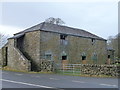
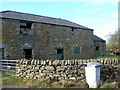
Old barn at Cernioge Mawr on the A5 near Cerrigydrudion
Now just a barn - but once Queen Victoria stopped here (well, in the yard anyway) for a brew. Was she amused? I trust that she was.
Image: © Jeremy Bolwell
Taken: 20 Jan 2012
0.06 miles
4
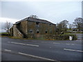
Farm building at Cernioge Mawr near Cerrigydrudion
I must have passed this distinctive building many times and it has always made me think 'why is it so ornate?' so today I stopped off briefly to take a photo with a view to researching it for geograph. Turns out it was built beside the new Holyhead road, now the A5 of course, to enable horses to be changed and to offer refreshment to passengers who would have to stretch their legs in the interval between teams. Apparently Queen Victoria, no less, was one such passenger who stopped here for a cup of tea.
The building is part of an old farm now farmed by a local farmer who breeds prize rams and sheep here. The glories are fading fast but the fittings declare its past status. I suppose it was an early equivalent of our motorway services.
Image: © Jeremy Bolwell
Taken: 20 Jan 2012
0.06 miles
5
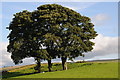
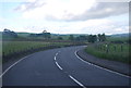
Trees beside the A5
Trees beside the A5 near Rhydlydan.
Image: © Philip Halling
Taken: 2 Sep 2012
0.07 miles
6
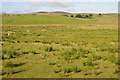
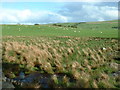
Upland grazing near Rhydlydan
Upland grazing viewed from the A5 to the east of near Rhydlydan.
Image: © Philip Halling
Taken: 2 Sep 2012
0.07 miles
7
Barn at Ceirnioge Fawr
On the north side of the A5, this barn belongs to Ceirnioge Fawr, a farm where Queen Victoria is said to have stopped. It was on the highway to Holyhead and Ireland and a changing place for stage horses.
Image: © Eirian Evans
Taken: 16 Nov 2007
0.09 miles
8
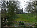
Cernioge Mawr
Samuel Spiker says of this house, in his book "Travels Through England Wales and Scotland in the Year 1816" - "... at the inn of Cernioge Mawr, I can truly say that .. I owe some of the most agreeable hours I enjoyed during my stay in England." He found it extremely comfortable and the landlady's daughter played Welsh airs on the harp.
Image: © Eirian Evans
Taken: 16 Apr 2008
0.09 miles