IMAGES TAKEN NEAR TO
Penmachno, BETWS-Y-COED, LL24 0PP
Introduction
This page details the photographs taken nearby to LL24 0PP by members of the Geograph project.
The Geograph project started in 2005 with the aim of publishing, organising and preserving representative images for every square kilometre of Great Britain, Ireland and the Isle of Man.

There are currently over 7.5m images from over14,400 individuals and you can help contribute to the project by visiting https://www.geograph.org.uk
Image Map
Images are licensed for reuse under creativecommons.org/licenses/by-sa/2.0
Notes
- Clicking on the map will re-center to the selected point.
- The higher the marker number, the further away the image location is from the centre of the postcode.
Image Listing (27 Images Found)
Images are licensed for reuse under creativecommons.org/licenses/by-sa/2.0
Image
Details
Distance
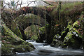
1

Pandy Bridge over the River Machno
This is a view of the road bridge from near the Roman Bridge
Image: © Eirian Evans
Taken: 21 Jan 2009
0.02 miles
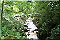
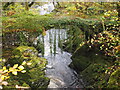
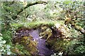
2
Roman Bridge & River Machno, Penmachno
Not Roman although it's named on the OS map. It looks more 17th century. The bridge crosses the River Machno
Image: © Brian Deegan
Taken: 14 Aug 2021
0.02 miles
3
Penmachno Woollen Mill by The River Machno
Now disused. Close to the confluence of the Machno and Conwy rivers.
Image: © Neil Theasby
Taken: 7 Apr 2017
0.02 miles
4
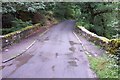
Roadbridge near Penmachno Woollen Mill
This roadbridge spans the Afon Machno close to the disused Penmachno Woollen Mill at grid reference SH 80662 52903.
Image: © Terry Hughes
Taken: 23 Aug 2006
0.03 miles
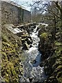
5
Pandy Falls
Taken from the modern bridge across the Afon Machno facing SW (up river)
Image: © Damon Knight
Taken: 22 Jul 2009
0.04 miles
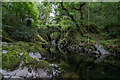
7
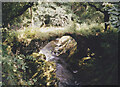
Roman Bridge on Afon Machno
This bridge is located behind the Penmachno Mill buildings. Its attribution to the Romans is fancifull.
Image: © Eric Jones
Taken: 4 Aug 2000
0.04 miles
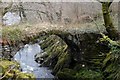
8
Ancient and modern bridges at Penmachno
Although the ancient footbridge (nearer to the photographer) is labelled "Roman Bridge" on the map, the Ordnance Survey has chosen to use the gothic font indicating "other antiquity" rather than the sans serif font it uses for things actually dating from the Roman occupation, implying either doubt over its Romanness or certainty over its non-Romanness. It is certainly a bit old - and has fierce signs suggesting that one would be risking one's safety (or perhaps that of the bridge) if attempting to cross over it. It would certainly be a shame to cause its collapse, especially as there is a perfectly serviceable modern bridge just beyond. Assuming enough sense not to risk the crossing, the major danger here is from the nettles and tripping-hazard tree roots one must negotiate to get the photograph. The tripod has to sit well out into the water to get this view, too !
Image: © Andy Waddington
Taken: 1 Dec 2018
0.04 miles
9
Pont dros Afon Machno / Bridge over Afon Machno
Image: © Ceri Thomas
Taken: 11 Feb 2013
0.04 miles
10
"Roman Bridge"
Actually a medieval pack bridge crossing Afon Machno
Image: © Damon Knight
Taken: 22 Jul 2009
0.04 miles