IMAGES TAKEN NEAR TO
Llanrwst Road, BETWS-Y-COED, LL24 0HD
Introduction
This page details the photographs taken nearby to Llanrwst Road, LL24 0HD by members of the Geograph project.
The Geograph project started in 2005 with the aim of publishing, organising and preserving representative images for every square kilometre of Great Britain, Ireland and the Isle of Man.

There are currently over 7.5m images from over14,400 individuals and you can help contribute to the project by visiting https://www.geograph.org.uk
Image Map
Images are licensed for reuse under creativecommons.org/licenses/by-sa/2.0
Notes
- Clicking on the map will re-center to the selected point.
- The higher the marker number, the further away the image location is from the centre of the postcode.
Image Listing (21 Images Found)
Images are licensed for reuse under creativecommons.org/licenses/by-sa/2.0
Image
Details
Distance
1
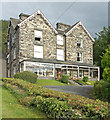
Park Hill Guest House / Gwesty Bryn Parc, Betws-y-Coed
Image: © MrC
Taken: 2 Aug 2012
0.01 miles
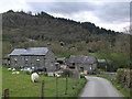
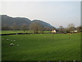
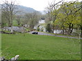
6
Muriau
Farm in the Conwy Valley near Betws y Coed
Image: © Eirian Evans
Taken: 16 Apr 2019
0.15 miles
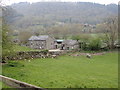
7
Muriau Farm
As viewed from the A470 road. The suspension bridge across the Afon Conwy is in mid centre of the photograph behind the farmhouse.
Image: © Richard Hoare
Taken: 16 Jan 2012
0.15 miles
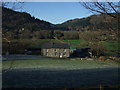
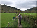
8
Track to Muriau Farm
A public footpath which takes you through the farmland and across the suspension bridge across the Afon Conwy to Betws-y-Coed from A470. Dogs need to be kept under control - sheep and chickens roam.
Image: © Richard Hoare
Taken: 16 Jan 2012
0.15 miles
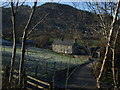
10
Path between Muriau Farm and Church Road, Betws y coed
Image: © Gary Rogers
Taken: 15 Apr 2017
0.19 miles