IMAGES TAKEN NEAR TO
BETWS-Y-COED, LL24 0AR
Introduction
This page details the photographs taken nearby to LL24 0AR by members of the Geograph project.
The Geograph project started in 2005 with the aim of publishing, organising and preserving representative images for every square kilometre of Great Britain, Ireland and the Isle of Man.

There are currently over 7.5m images from over14,400 individuals and you can help contribute to the project by visiting https://www.geograph.org.uk
Image Map
Images are licensed for reuse under creativecommons.org/licenses/by-sa/2.0
Notes
- Clicking on the map will re-center to the selected point.
- The higher the marker number, the further away the image location is from the centre of the postcode.
Image Listing (100 Images Found)
Images are licensed for reuse under creativecommons.org/licenses/by-sa/2.0
Image
Details
Distance
1

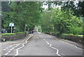
The A5 Holyhead Road, Betws y Coed, and a milestone
Looking along the A5 Holyhead Road/Ffordd Caergybi towards the famous Waterloo Bridge. On the left is one of Thomas Telford's milestones - Image
Image: © John S Turner
Taken: 12 Feb 2019
0.02 miles
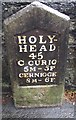
4
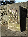
Telford Milestone on the A5, Betws-y-Coed
HOLYHEAD 45
C.CURIG 5M-5F
CERNIOGE 8M-6F
For more details of benchmark see: https://www.bench-marks.org.uk/bm25983
Image: © Meirion
Taken: 17 Oct 2023
0.03 miles
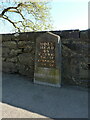
5
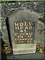
Old Milestone by the A5, south east of Betws-y-Coed
Telford Plate by the A5, in parish of Betws-y-Coed (Conwy County Borough District), East of Betws-y-Coed nearly opposite Little Chef, in pavement with back to dry stone wall.
Inscription reads:-
HOLY-
HEAD
45
C.CURIG
5M-5F
CERNIOGE
8M-6F
Carved bench mark on lower face.
Grade II listed by Cadw.
Reference Number: 17828 https://cadwpublic-api.azurewebsites.net/reports/listedbuilding/FullReport?lang=&id=17828
Surveyed
Milestone Society National ID: CAE_HH45
Image: © Milestone Society
Taken: Unknown
0.03 miles
6

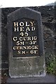
Milestone in Holyhead Road/Ffordd Caergybi, Betws y Coed
This Thomas Telford style milestone stands alongside the A5 Holyhead Road/Ffordd Caergybi in Betws y Coed. The inscription on the cast plate reads:
HOLY-HEAD 45
C,CURIG 5M - 5F
CERNIOGE 8M - 6F
Milestone Society Reference is: CAE_HH45
There is an Ordnance Survey bench mark at the base of the stone.
Bench mark database reference: https://www.bench-marks.org.uk/bm25983
For a wider view see: Image
Image: © John S Turner
Taken: 12 Feb 2019
0.03 miles
7
Mile Stone - Capel Curig 5
There is an OS cut mark on the stone. It marks a point 20.488m above mean sea level.
Image: © Adrian Dust
Taken: 27 Sep 2016
0.03 miles
8
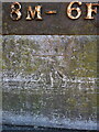
OS benchmark - Betws-y-Coed milestone
Cut into the lower part of the Image, and last levelled in 1968 at 20.488m above Ordnance Datum Newlyn, this mark also appears on older maps at 66.9ft Liverpool datum.
Image: © Richard Law
Taken: 20 Apr 2023
0.03 miles
9
Telford milestone on the A5, south of Betws-y-Coed
One of the original milestones erected around 1815 when the London to Holyhead road was being improved through North Wales by the engineer Thomas Telford. It's made of solid stone with a cast iron plaque, and was Grade II listed https://britishlistedbuildings.co.uk/300017828-milestone-betws-y-coed & https://cadwpublic-api.azurewebsites.net/reports/listedbuilding/FullReport?lang=en&id=17828 in 1996.
Image: © Richard Law
Taken: 20 Apr 2023
0.03 miles
10
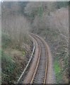
Tro ar Reilffordd Dyffryn Conwy / Bend on the Conwy Valley Railway
This is one of many sharp bends on the southern section of the Conwy Valley Railway.
Image: © Ceri Thomas
Taken: 2 Feb 2014
0.04 miles