IMAGES TAKEN NEAR TO
Parc, BALA, LL23 7YN
Introduction
This page details the photographs taken nearby to LL23 7YN by members of the Geograph project.
The Geograph project started in 2005 with the aim of publishing, organising and preserving representative images for every square kilometre of Great Britain, Ireland and the Isle of Man.

There are currently over 7.5m images from over14,400 individuals and you can help contribute to the project by visiting https://www.geograph.org.uk
Image Map
Images are licensed for reuse under creativecommons.org/licenses/by-sa/2.0
Notes
- Clicking on the map will re-center to the selected point.
- The higher the marker number, the further away the image location is from the centre of the postcode.
Image Listing (5 Images Found)
Images are licensed for reuse under creativecommons.org/licenses/by-sa/2.0
Image
Details
Distance
1
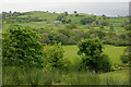
Farmland around Plas Madog
Mainly fields with some woodland, characteristic of much of this square.
Image: © Nigel Brown
Taken: 27 May 2009
0.07 miles
2
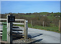
Plas Madog
Entrance to the farm that is situated in the Afon Llafar valley near Llyn Tegid (Lake Bala).
Image: © michael ely
Taken: 28 Apr 2006
0.16 miles
3
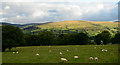
Field with sheep near Plas Madog
The sunlit dome in the centre of the image rises to 490m on the south-east side of Lake Bala; beyond it can be seen some of the higher ground of the Berwyn Mountains.
Image: © Trevor Littlewood
Taken: 18 Sep 2013
0.20 miles
4
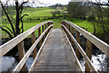
New footbridge
This footbridge should win prizes.
Over the Afon Llafar
Image: © Rick Crowley
Taken: 15 Apr 2011
0.21 miles
5
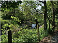
Afon Llafar
Afon Llafar is a small river which rises on the eastern slopes of Arenig Fawr, and flows south-east through the hamlet of Parc and into Bala Lake
Image: © Eirian Evans
Taken: 23 May 2018
0.24 miles