IMAGES TAKEN NEAR TO
Llandderfel, BALA, LL23 7RL
Introduction
This page details the photographs taken nearby to LL23 7RL by members of the Geograph project.
The Geograph project started in 2005 with the aim of publishing, organising and preserving representative images for every square kilometre of Great Britain, Ireland and the Isle of Man.

There are currently over 7.5m images from over14,400 individuals and you can help contribute to the project by visiting https://www.geograph.org.uk
Image Map (Loading...)


Getting Data...Please wait
Leaflet Map data © OpenStreetMap
Images are licensed for reuse under creativecommons.org/licenses/by-sa/2.0
Notes
- Clicking on the map will re-center to the selected point.
- The higher the marker number, the further away the image location is from the centre of the postcode.
Image Listing (8 Images Found)
Images are licensed for reuse under creativecommons.org/licenses/by-sa/2.0
Image
Details
Distance
3
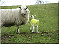
This season's fashion!
This little lamb was modelling a yellow plastic jacket on a cold rainy afternoon.
Image: © liz dawson
Taken: 28 Mar 2008
0.13 miles
7
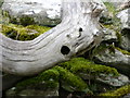
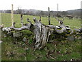
Stricken tree trunk!
The ancient Celts saw animals in nature in trees rocks etc. this tree trunk caught our eye as we walked past.
Image: © liz dawson
Taken: 28 Mar 2008
0.23 miles