IMAGES TAKEN NEAR TO
Llandderfel, BALA, LL23 7RD
Introduction
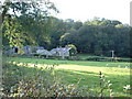
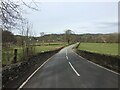
This page details the photographs taken nearby to LL23 7RD by members of the Geograph project.
The Geograph project started in 2005 with the aim of publishing, organising and preserving representative images for every square kilometre of Great Britain, Ireland and the Isle of Man.

There are currently over 7.5m images from over14,400 individuals and you can help contribute to the project by visiting https://www.geograph.org.uk
Image Map
Images are licensed for reuse under creativecommons.org/licenses/by-sa/2.0
Notes
- Clicking on the map will re-center to the selected point.
- The higher the marker number, the further away the image location is from the centre of the postcode.
Image Listing (3 Images Found)
Images are licensed for reuse under creativecommons.org/licenses/by-sa/2.0
Image
Details
Distance
3
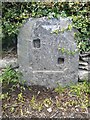
Old Milestone by the B4401, south of Llanderfel, Llandderfel Parish
By the B4401, in parish of Llandderfel (Gwynedd District), Llandderfel, 200m South West of war memorial on narrow verge, West side of road.
Inscription once read:- : (Bala 4 / Corwen 9) :
To be surveyed
Milestone Society National ID: MER_BACN04
Image: © Milestone Society
Taken: Unknown
0.11 miles