IMAGES TAKEN NEAR TO
Llandderfel, BALA, LL23 7PY
Introduction
This page details the photographs taken nearby to LL23 7PY by members of the Geograph project.
The Geograph project started in 2005 with the aim of publishing, organising and preserving representative images for every square kilometre of Great Britain, Ireland and the Isle of Man.

There are currently over 7.5m images from over14,400 individuals and you can help contribute to the project by visiting https://www.geograph.org.uk
Image Map (Loading...)


Getting Data...Please wait
Leaflet Map data © OpenStreetMap
Images are licensed for reuse under creativecommons.org/licenses/by-sa/2.0
Notes
- Clicking on the map will re-center to the selected point.
- The higher the marker number, the further away the image location is from the centre of the postcode.
Image Listing (5 Images Found)
Images are licensed for reuse under creativecommons.org/licenses/by-sa/2.0
Image
Details
Distance
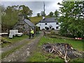
3
Looking towards Bwlch-y-safn cottage
Here's a rare typo from the OS - the cottage name is recorded as Bwich-y-safn (with an i instead of an l) on the 1:25000 series. I have reported it.
Image: © David Medcalf
Taken: 3 May 2019
0.12 miles
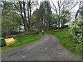
4
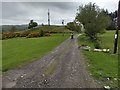
The bridleway near Bryn-Meredydd radio mast
Image: © David Medcalf
Taken: 3 May 2019
0.17 miles