IMAGES TAKEN NEAR TO
Station Road, BALA, LL23 7NG
Introduction
This page details the photographs taken nearby to Station Road, LL23 7NG by members of the Geograph project.
The Geograph project started in 2005 with the aim of publishing, organising and preserving representative images for every square kilometre of Great Britain, Ireland and the Isle of Man.

There are currently over 7.5m images from over14,400 individuals and you can help contribute to the project by visiting https://www.geograph.org.uk
Image Map (Loading...)


Getting Data...Please wait
Leaflet Map data © OpenStreetMap
Images are licensed for reuse under creativecommons.org/licenses/by-sa/2.0
Notes
- Clicking on the map will re-center to the selected point.
- The higher the marker number, the further away the image location is from the centre of the postcode.
Image Listing (185 Images Found)
Images are licensed for reuse under creativecommons.org/licenses/by-sa/2.0
Image
Details
Distance
1
Heol yr Orsaf (Station Road), Bala
Heol yr Orsaf (or Station Road in the English language) is on the route of the A494 road as it passes through the town of Bala, on the edge of Snowdonia National Park. The road led to Bala's railway station, which closed in 1965.
Image: © Malc McDonald
Taken: 11 Aug 2023
0.01 miles
2

Ordnance Survey Flush Bracket (S0436)
This OS Flush Bracket can be found on the NE face of the old school building. It marks a point 166.435m above mean sea level.
Image: © Adrian Dust
Taken: 3 Apr 2015
0.02 miles
3
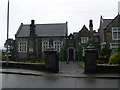
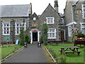
Neuadd y Cyfnod, Bala
This hall, now a restaurant, used to be the old Grammar School at Bala. It had a close connection with Jesus College, Oxford, and the coat of arms of the college is shown on the front wall of the building. Edward Meyrick, born near Corwen, bequeathed money to build the school and he also bequeathed a large sum of money to Jesus College.
Image: © Eirian Evans
Taken: 20 Jul 2010
0.03 miles
4
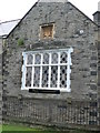
The gable end of Neuadd y Cyfnod
The coat of arms of Jesus College, Oxford, on the gable end of Neuadd y Cyfnod.Image
Image: © Eirian Evans
Taken: 20 Jul 2010
0.03 miles
8
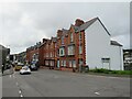
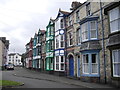
A terrace of large Victorian houses at the bottom of Ffrydan Road
Image: © Eric Jones
Taken: 8 Jun 2007
0.04 miles
9

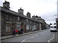
Car park, Bala
Car park located at the east end of Bala on the B4391. The Car Park shown is sited on what used to be the Town Green, which was adjacent to the railway station. The Old School Restaurant is the imposing stone-built building at the centre of the photograph. The low building on the left used to be the lower forms and workshop of the school, but now houses the County Printing Press. The School, which was bequeathed to Bala and the surrounding district in 1712 by Edmund Meyricke, an Oxford Scholar, provided education for boys of the area until the Comprehensive School, Ysgol y Berwyn, was opened in 1964.
Image: © Oliver Dixon
Taken: 22 Jun 2006
0.04 miles
10
Neuadd y Cyfnod, Bala
This hall, now a restaurant, used to be the old Grammar School at Bala. It had a close connection with Jesus College, Oxford, and the coat of arms of the college is shown on the front wall of the building. Edward Meyrick, born near Corwen, bequeathed money to build the school and he also bequeathed a large sum of money to Jesus College.
Image: © Eirian Evans
Taken: 12 May 2007
0.04 miles