IMAGES TAKEN NEAR TO
Cefn Ddwysarn, BALA, LL23 7HF
Introduction
This page details the photographs taken nearby to LL23 7HF by members of the Geograph project.
The Geograph project started in 2005 with the aim of publishing, organising and preserving representative images for every square kilometre of Great Britain, Ireland and the Isle of Man.

There are currently over 7.5m images from over14,400 individuals and you can help contribute to the project by visiting https://www.geograph.org.uk
Image Map
Images are licensed for reuse under creativecommons.org/licenses/by-sa/2.0
Notes
- Clicking on the map will re-center to the selected point.
- The higher the marker number, the further away the image location is from the centre of the postcode.
Image Listing (4 Images Found)
Images are licensed for reuse under creativecommons.org/licenses/by-sa/2.0
Image
Details
Distance
2
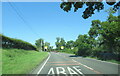
The A494 north at Cefn-ddwysarn village sign
Image: © Roy Hughes
Taken: 10 Aug 2022
0.13 miles
4
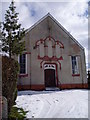
Cefnddwysarn Chapel
Calvinistic Methodist chapel at Cefnddwysarn, near Bala
Image: © Eirian Evans
Taken: 6 Mar 2006
0.15 miles