IMAGES TAKEN NEAR TO
Rhosygwalia, BALA, LL23 7ES
Introduction
This page details the photographs taken nearby to LL23 7ES by members of the Geograph project.
The Geograph project started in 2005 with the aim of publishing, organising and preserving representative images for every square kilometre of Great Britain, Ireland and the Isle of Man.

There are currently over 7.5m images from over14,400 individuals and you can help contribute to the project by visiting https://www.geograph.org.uk
Image Map (Loading...)


Getting Data...Please wait
Leaflet Map data © OpenStreetMap
Images are licensed for reuse under creativecommons.org/licenses/by-sa/2.0
Notes
- Clicking on the map will re-center to the selected point.
- The higher the marker number, the further away the image location is from the centre of the postcode.
Image Listing (18 Images Found)
Images are licensed for reuse under creativecommons.org/licenses/by-sa/2.0
Image
Details
Distance
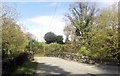
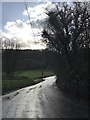
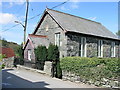
2
Rhos-y-gwaliau
Looking towards the road junction on the edge of the village.
Image: © Peter Morgan
Taken: 4 Sep 2012
0.04 miles
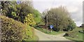
6
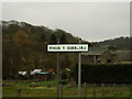
Approaching Rhos-y-Gwaliau from the north
Image: © Eirian Evans
Taken: 20 Mar 2006
0.05 miles
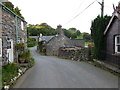
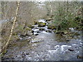
9
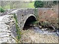
Bridge over the River Hirnant at Rhos-y-Gwaliau
Image: © Eirian Evans
Taken: 20 Mar 2006
0.12 miles