IMAGES TAKEN NEAR TO
Borth Crossroads, ABERGELE, LL22 9SB
Introduction
This page details the photographs taken nearby to Borth Crossroads, LL22 9SB by members of the Geograph project.
The Geograph project started in 2005 with the aim of publishing, organising and preserving representative images for every square kilometre of Great Britain, Ireland and the Isle of Man.

There are currently over 7.5m images from over14,400 individuals and you can help contribute to the project by visiting https://www.geograph.org.uk
Image Map (Loading...)


Getting Data...Please wait
Leaflet Map data © OpenStreetMap
Images are licensed for reuse under creativecommons.org/licenses/by-sa/2.0
Notes
- Clicking on the map will re-center to the selected point.
- The higher the marker number, the further away the image location is from the centre of the postcode.
Image Listing (6 Images Found)
Images are licensed for reuse under creativecommons.org/licenses/by-sa/2.0
Image
Details
Distance
1
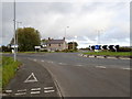
Porth Farm
Near the roundabout at the junction of Rhuddlan Road and St Asaph Avenue
Image: © Eirian Evans
Taken: 21 Oct 2019
0.00 miles
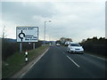
3
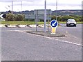
Borth Cross Roads
This used to be a major vehicle accident spot until the roundabout was built.
Image: © David and Rachel Landin
Taken: 30 Jul 2005
0.12 miles
4
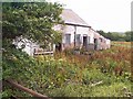
Old Farm buildings now used as stables
These stables house small Shetland ponies.
Image: © David and Rachel Landin
Taken: 30 Jul 2005
0.12 miles
5
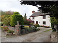
Glasfryn
Cottage on Rhuddlan Road, north of Bodelwyddan
Image: © Eirian Evans
Taken: 21 Oct 2019
0.14 miles
6
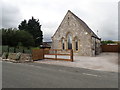
Morfa Chapel
Morfa Methodist Chapel was built in 1866, in the Gothic style.
Image: © Eirian Evans
Taken: 21 Oct 2019
0.18 miles