IMAGES TAKEN NEAR TO
St. George, ABERGELE, LL22 9RT
Introduction
This page details the photographs taken nearby to LL22 9RT by members of the Geograph project.
The Geograph project started in 2005 with the aim of publishing, organising and preserving representative images for every square kilometre of Great Britain, Ireland and the Isle of Man.

There are currently over 7.5m images from over14,400 individuals and you can help contribute to the project by visiting https://www.geograph.org.uk
Image Map (Loading...)


Getting Data...Please wait
Leaflet Map data © OpenStreetMap
Images are licensed for reuse under creativecommons.org/licenses/by-sa/2.0
Notes
- Clicking on the map will re-center to the selected point.
- The higher the marker number, the further away the image location is from the centre of the postcode.
Image Listing (3 Images Found)
Images are licensed for reuse under creativecommons.org/licenses/by-sa/2.0
Image
Details
Distance
1
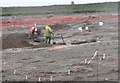
Archaeologists working near Dinorben, St. George.
This is a view of the Archaeological dig taking place near Dinorben, St. George. The field you see in this view is programmed to be blown to pieces, as the St. George Quarry expands. The St. George Quarry has already removed a hill fort off the map. What price progress?
Image: © Stephen Elwyn RODDICK
Taken: 23 Feb 2006
0.11 miles
2
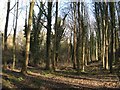
Coed Pen-y-bryn
Woodland at the roadside is free of leafy canopy and shows shadow patterns in the low, winter light.
Image: © Jonathan Wilkins
Taken: 12 Feb 2018
0.16 miles
3
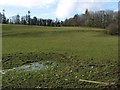
Pen-y-bryn pasture
A wet patch on pasture enclosed on three sides by Coed Pen-y-bryn.
Image: © Jonathan Wilkins
Taken: 12 Feb 2018
0.19 miles