IMAGES TAKEN NEAR TO
Moelfre, ABERGELE, LL22 9RH
Introduction
This page details the photographs taken nearby to LL22 9RH by members of the Geograph project.
The Geograph project started in 2005 with the aim of publishing, organising and preserving representative images for every square kilometre of Great Britain, Ireland and the Isle of Man.

There are currently over 7.5m images from over14,400 individuals and you can help contribute to the project by visiting https://www.geograph.org.uk
Image Map
Images are licensed for reuse under creativecommons.org/licenses/by-sa/2.0
Notes
- Clicking on the map will re-center to the selected point.
- The higher the marker number, the further away the image location is from the centre of the postcode.
Image Listing (7 Images Found)
Images are licensed for reuse under creativecommons.org/licenses/by-sa/2.0
Image
Details
Distance
1
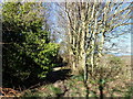
Bridleway heading north towards Abergele
Image: © Eirian Evans
Taken: 26 Feb 2019
0.08 miles
2
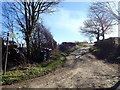
Farm track and bridleway on Moelfre Isaf
Image: © Eirian Evans
Taken: 26 Feb 2019
0.11 miles
3
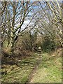
Bridleway to Moelfre
This part of the bridleway is not used as a farm track, and is less well-trodden as a result. It does suffer from the common problem of a median stream, especially after recent rain and snow. See also Image
Image: © Jonathan Wilkins
Taken: 5 Apr 2018
0.21 miles
5
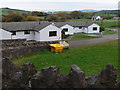
Lakeside Cottages
Built near the five lakes of Tan y Mynydd Fishery at Moelfre
Image: © Eirian Evans
Taken: 16 Nov 2007
0.22 miles
6
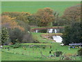
Tan y Mynydd Fishery
A trout fishery nestling in the countryside south of Abergele; there are five lakes here.
Image: © Eirian Evans
Taken: 16 Nov 2007
0.23 miles
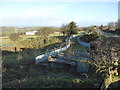
7
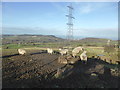
Viewpoint below Moelfre
See: http://www.geograph.org.uk/photo/2531798
It's December now...the cow has been replaced by sheep and the grass by mud.
Image: © David Medcalf
Taken: 30 Dec 2014
0.24 miles