IMAGES TAKEN NEAR TO
Llanfairtalhaiarn, ABERGELE, LL22 9RB
Introduction
This page details the photographs taken nearby to LL22 9RB by members of the Geograph project.
The Geograph project started in 2005 with the aim of publishing, organising and preserving representative images for every square kilometre of Great Britain, Ireland and the Isle of Man.

There are currently over 7.5m images from over14,400 individuals and you can help contribute to the project by visiting https://www.geograph.org.uk
Image Map (Loading...)


Getting Data...Please wait
Leaflet Map data © OpenStreetMap
Images are licensed for reuse under creativecommons.org/licenses/by-sa/2.0
Notes
- Clicking on the map will re-center to the selected point.
- The higher the marker number, the further away the image location is from the centre of the postcode.
Image Listing (3 Images Found)
Images are licensed for reuse under creativecommons.org/licenses/by-sa/2.0
Image
Details
Distance
1
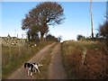
Track to Pant-y-carw
The lane to Pant-y-carw climbs briefly from the road. It is notable that walls here are made with quarried stone, there being an apparent dearth of glacially-derived material.
Image: © Jonathan Wilkins
Taken: 1 Dec 2016
0.10 miles
2
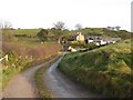
Pant-y-carw
The farm and cottage at Pant-y-carw seen from the lane which carries a footpath.
Image: © Jonathan Wilkins
Taken: 1 Dec 2016
0.18 miles
3
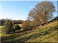
Footpath to Pant-y-carw
The footpath to Pant-y-carw climbs out of the dingle and heads along the hedge beneath these magnificent trees.
Image: © Jonathan Wilkins
Taken: 1 Dec 2016
0.22 miles