IMAGES TAKEN NEAR TO
Gors Road, ABERGELE, LL22 9NR
Introduction
This page details the photographs taken nearby to Gors Road, LL22 9NR by members of the Geograph project.
The Geograph project started in 2005 with the aim of publishing, organising and preserving representative images for every square kilometre of Great Britain, Ireland and the Isle of Man.

There are currently over 7.5m images from over14,400 individuals and you can help contribute to the project by visiting https://www.geograph.org.uk
Image Map (Loading...)


Getting Data...Please wait
Leaflet Map data © OpenStreetMap
Images are licensed for reuse under creativecommons.org/licenses/by-sa/2.0
Notes
- Clicking on the map will re-center to the selected point.
- The higher the marker number, the further away the image location is from the centre of the postcode.
Image Listing (9 Images Found)
Images are licensed for reuse under creativecommons.org/licenses/by-sa/2.0
Image
Details
Distance
1
North Coast Church, Towyn
Church affiliated to UK Assemblies of God network and Evangelical Alliance Cymru.
Image: © Eirian Evans
Taken: 21 Mar 2012
0.06 miles
2

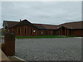
Church of Christ the King
A very functional but attractive catholic church on Gors Road.
Image: © Jonathan Wilkins
Taken: 21 Oct 2008
0.08 miles
3

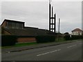
Steeple, Christ the King
The innovative design of the church does not lend itself to a steeple, so a wooden, triangular structure stands apart from the building. I tried very hard, but failed to include the crucifix in an image which also shows the building.
Image: © Jonathan Wilkins
Taken: 21 Oct 2008
0.08 miles
5
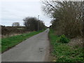
Kinmel Way
Road running east-west on the southern outskirts of Towyn
Image: © Eirian Evans
Taken: 21 Mar 2012
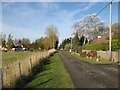
0.15 miles
6
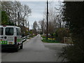
Towyn Way East
No through road, ending in a turning place near the Gele river.
Image: © Eirian Evans
Taken: 21 Mar 2012
0.19 miles
7

Maranatha Hall, Towyn
The Churches of God "guard the good deposit" by maintaining first century Bible convictions while aiming to keep pace with the pulse-beat of modern society.
Image: © Eirian Evans
Taken: 21 Mar 2012
0.19 miles
8
Towyn Way East
A road with various housing that stretches out into Morfa Rhuddlan.
Image: © Jonathan Wilkins
Taken: 11 Nov 2016
0.21 miles
9
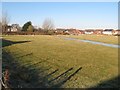
Flooded pasture, Rhodfa Nant
A bit of green still holding its own against the encroachment of new housing.
Image: © Jonathan Wilkins
Taken: 25 Nov 2016
0.21 miles